Waterfalls along the Bruce Trail : McDui Access to Buttermilk Falls, Hamilton
Waterfalls along the Bruce Trail
Bruce Trail Iroquoia Section
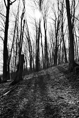
After delays, owing to weather, circumstances, and family obligations we finally got back out hiking on the Bruce Trail with the goal being to get north of Hamilton before the heat of the summer months set in. We started this trek at the McDui Drive Access trail where we had previously left off.

When we arrived at the trailhead it was sunny and cold out though ultimately the weather was great for hiking! Lenora had just celebrated her birthday and was trying out her new gaiters and day pack. While initially the trail looked frozen, the reality was that only a few feet in from the parking access we discovered that the prolific mud was only partially solid. As the day unfolded it turned out that the gaiters were a good choice as the warm spring weather combined with cooler nights meant that the Bruce Trail was alternatively frozen in some places while muddy in sections.


Back on the Bruce Trail
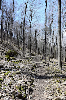
Back on the main BTC pathway we almost immediately crossed DeWitt Rd. A small "waterfall" was visible above the trail, on the south side of DeWitt which was still mostly frozen fingers of ice extending down the side of the exposed escarpment rather than a running waterfall. As we walked from the McDui Access trail, past Dewitt Rd, the Millen Rd Access, and the Oakridge Drive Access Trails the pathway wove through a forest and seemed to dip and climb a little, but largely remained in the woods mid-way up the escarpment. That said there were also times that we would steeply ascend to the top of the escarpment and then just as quickly descend to the subdivisions below. The neighbourhoods at the base of the escarpment mostly consisted of large, relatively new houses, and many had in-ground pools as well as landscaped yards which seemed to contrast with the natural setting of the Bruce Trail nearby.


Urban Trails, City Trekking
Beyond the neighborhoods adjacent to the trail a definite change in the landscape was evident. The land between the pathway and the lake was definitely more urban now, filled with subdivisions, apartment buildings, and industrial complexes rather than the vineyards and agricultural fields that we had seen in past hikes. It was a clear day, so from our occasional visits to the ridge of the Niagara Escarpment, we could see across the dark turquoise waters of Lake Ontario as well as the city centers of Hamilton, Burlington, Mississauga, and Toronto. In the foreground we could recognize the bridge over Hamilton Harbour, HWY 6 heading north to Guelph, and the globe of the water treatment facility in Hamilton. More than ever it was clear that on the BTC we travelled in a green corridor which had survived from development only through constant protection.


Devil's Punch Bowl
As the trail approached New Mountain Rd we ascended at a point where the pathway merged with a local railway track to pass under the road before ducking back into the woods. At kilometre 19.4 we decided to depart from the main Bruce Trail onto the Devil's Punch Bowl Side Trail to see the waterfalls. As a result, we had a steep climb along some rather narrow stairs that made me grateful it wasn't raining and slippery. Soon the pathway took us over the lip of the escarpment into a grassy field, beyond which was a parking lot.


Alongside us there was a gravel path leading to a fenced-in lookout, complete with benches and a large metal cross perched on the upper ridge of the escarpment. The view from this lookout was spectacular and gave us a wonderful perspective over Hamilton, and north across Lake Ontario.


The waterfall is a straight ribbon of water that falls uninterrupted from the top to the bottom of the escarpment, and over time it has hollowed out a huge C-shaped bowl. The walls of the bowl exhibit vivid stripes of light dusty green and dark rusty red stone, as well as the greyish/yellowish bands typical of much of the escarpment. It was a very striking and beautiful sight.

While standing here marvelling at Devil’s Punch Bowl I was struck by the contrast in this area to just a few short weeks beforehand when the falls were still frozen and iced over.


Bakeries and Battlefields
Today the parking lot for the falls was full with many families out and about, enjoying the spring sunshine. While we were taking in the view of the falls, we spotted the Devil's Punch Bowl bakery and Country Market, which is located on the south side of Ridge Rd., just across from our location. Unable to resist we decided to check out the offerings and were pleased to find that it was open 7 days a week from April 1st to December. The smell of baked goods was overwhelming when we went inside, and if we had been in possession of a car we would have come away with at least a pie and a quiche, if not more. As it was, we "settled" for several types of cookies and a chocolate chip loaf to compliment our lunches which we enjoyed outside. Lenora chose a very nice-looking butter tart, as well as some additional goodies to share with the folks at home. The two-legged members of our group were not the only ones to enjoy a few treats however as Mackenzie was also able to enjoy a few dog cookies and water during our break.

Here we also discovered the Dofasco 2000 Trail, a short 11.5 km local pathway which passes near to the Devil's Punch Bowl waterfalls and links the region to a range of Conservation Areas, marshes, swamps, and birding meadows!


After about an hour of enjoying a break, we resumed hiking along the Bruce Trail descending along a side trail back down the escarpment to the main route. Here we came to a road underpass along a railway whose bridge supports were blazed – reminding us that blazes could be found in all sorts of unique places!


Battlefield House National Historic Site
Having made it across the busy roadway we took the opportunity to again meander off the Bruce Trail and to visit Battlefield House Museum & Park National Historic Site which was located nearby. This location is an acreage of the 19th-century Battlefield House which served as the homestead of the regionally important Gage family, and later the location of the Women’s Institute (1988-1962). The surrounding area is also notably the site of the Battle of Stoney Creek (1813) one of the most important battles in the British-American conflict.


Battlefield Monument
At the rear of the property of Stoney Creek Battlefield Park is the prominent Battlefield Monument a 100-foot-high monument structure which commemorates the fallen soldiers during the Battle of Stoney Creek. According to the historical information at the site, the Battlefield Monument was completed in 1913 – a century after the Battle of Stoney Creek – in the English Gothic Revival Style.
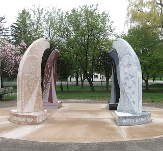


At the front of the National Historic Site is a beautiful piece of Indigenous artwork entitled “The Eagles Among Us” which was commissioned for the bicentennial of the War of 1812 and designed by David General, a Oneida member of the Six Nations of the Grand River and installed in 2014. This Indigenous artwork comprises four, nine-foot-tall granite eagles at the centre of a circular area reflecting the cultural traditions of the Haudenosaunee and Anishinabeck communities.


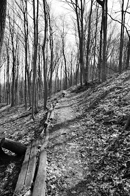
Forest Trails
Returning to the Bruce Trail we entered a section of wooded trail with quite a few shrubs along the sides of the trail. It was nice to be in the sun and out of the wind, and we quickly warmed up again. As we continued on, we came to a somewhat curious concrete and metal structure used for water diversion. There was a small, mossy stream/waterfall flowing down the escarpment, and near the bottom, it was diverted into a concrete flow, and then down through a metal grate into a deep, underground channel. In addition, as we continued along the trail, every once in a while, we passed by manhole covers on the forest floor where we could hear the sounds of water flowing. Not exactly the wilderness experience one expects on a trail in nature.


Hiking in Hamilton Ontario
By this point on the Bruce Trail having traversed the suburbs of Grimsby and subdivisions of Stoney Creek, we were now well into the City of Hamilton. Nicknamed the “Steel City” because Hamilton long stood as Canada’s largest steel producer and one of its most important Industrial ports, this town was built on the plains between the Niagara Escarpment and the large harbour below. The area was first noted to Europeans by French explorer Rene Robert de la Salle in 1669 and was developed later, in 1784 when the British government bought the land from the Mississauga Indigenous peoples to settle United Empire Loyalists who left the land following the American Revolution.


In the years since Hamilton has alternatively been known as Burlington Bay and King’s Head, before later being renamed after George Hamilton in 1825. Hamilton City is the home of the Canadian Football Hall of Fame, the Royal Botanical Gardens, the Canadian Warplane Heritage Museum, Dundurn Castle, and McMaster University. In addition to this, one of the main roadways which traverses Hamilton is the Lincoln Alexander Parkway, which is named after Canada’s First black member of parliament the Honourable Lincoln Alexander.


Felker's Falls Conservation Area
The Bruce Trail led us into Felker's Falls Conservation Area – which in many ways is simply a much smaller version of Devil's Punch Bowl Falls. Felker’s Falls stands 22 m or 72 feet high and is a ribbon fall. Here the trail went past the waterway, near the top where we were able to look down into the valley at the river fall below. Throughout much of this Conservation Area, the Bruce Trail is a flat paved pathway that follows the escarpment edge. At one lookout we could see Dundas Ontario – the home to a future hike on the Bruce Trail.

After the falls, we had a short walk to the edge of the park and emerged next to a neighbourhood, passing both the Paramount Park and the Kingsview Drive Side Trails.

At one point the BTC came to an end on what appeared to be an unused roadway where the white blazes which we follow disappeared! As a result for about half an hour, we had difficulties figuring out which direction we were supposed to proceed. There are no blazes visible in either direction, and it is possible to turn right and continue down the road, or go left and continue along a path that skirts the subdivision. From looking at the map we were able to figure out that we needed to turn right, and around a curve in the road/trail we were rewarded with a blaze indicating we should turn left and use the underpass for the upcoming highway.


Red Hill Valley Trail
Back on the Bruce Trail we soon trekked under the Red Hill Valley Parkway and joined with the aptly named Red Hill hiking trail. Here we found an Indigenous sitting area which we took to calling the “Bear area” as the stones here had been laid out in the shape of a large bear paw! After taking a brief break here to rest our legs, enjoy a snack, and explore the uniquely shaped sitting area, we continued north along the Red Hill Valley trail into the King’s Forest!


Much of the hike was reminiscent of previous areas we have trekked on the Bruce Trail, though the pathway now being within the boundaries and development of Hamilton. While much of the Bruce has been kept in a wonderful green corridor this stretch nonetheless exposes hikers to the increasing volume of city sounds, urban sites, residential signage and common waste. Perhaps the most unfortunate aspect of this hike was the large amount of Tim Hortons cups and Fast Food wrapping along the pathway. Why people feel compelled to fill tree stumps with beer cans and waste has always been a mystery to me.

Excited and enjoying our time today in Hamilton we finished our hike for the day, packed into our waiting vehicle and motored off to a local coffee shop to make plans for exploring Hamilton, its natural areas and taking on the challenging Steeltown Stomp in a few weekends!
-----
Distance: 15.7 - 27.5 km (Buttermilk Falls, on side-trail)
Duration: 10:30am - 4:30 pm (6 hours)
Comments
Post a Comment