Dufferin Hi-Land End-to-End Hike : Mono Cliffs to Whitfield
Dufferin Hi-Land End-to-End Hike
Since our Last Hike
The next portion of the Bruce Trail for us was the Dufferin Hi-Land Section, which means that over the last 18 hikes we have trekked around 340 kilometres since leaving Fort Erie on the Niagara Recreation Trail, and about 300 km kilometres since Queenston Heights. While this sounds impressive, the length of the Bruce Trail helps put it into perspective, given that we still have more than 550 km to go before arriving in Tobermory. As such our excitement is somewhat tempered.Dufferin Hi-Land End-to-End Hike on the Bruce Trail
As we did on the Caledon Hills section of the Bruce Trail, we are tackling the Dufferin Hi-Lands during an organized End-to-End event over the course of two days. While our first dozen hikes on the Bruce Trail were undertaken as a series of day treks, the distance from Simcoe, Ontario on the northern shores of Lake Erie to our present location on the BTC is now too far for day treks. This means that we are now taking the approach of travelling north, camping at an established provincial park, and completing an entire section in one go.
Bruce Trail Conservancy End-to-End Patch
Challenges and Benefits
While organized End-to-end events have a lot of benefits for those striving to hike the entire Bruce Trail, there are a few challenges. These weekend events do not necessarily follow the BTC in order, systematically moving hikers either south to north or north to south. Instead, the organizers typically choose a rallying point near the middle of the section, have everyone meet there each morning, and then bus the hike participants to a particular section. This means that one morning you might travel from the southern edge of the section to the middle, while the next day you might be hiking from the northern edge back to the centre. For those striving to get a feel for the trek in one direction, these events are somewhat discombobulating. However, this is a mild critique.
Back to the Bruce Trail
This morning we woke early, excited to get back to the Bruce Trail. We soon enjoyed a quick breakfast of oatmeal and coffee before cleaning up and setting off. The emailed instructions for the End-to-End event noted that the rally point this weekend was at the intersection of HWY 17 and Centre Rd, which is also known as Whitfield. Thankfully, we had a cell phone on us and were able to use Google Maps to find the inconspicuous red brick church situated on a remote corner of these two roadways. Upon arriving, we parked and locked the car and collected our backpacks..JPG)
Soon we
had registered and joined the lineup to board the bus to Mono Centre, which is
the dividing line between the Caledon Hills and Dufferin Hi-Land sections of
the BTC. Apparently, 95 people
pre-registered for this hike, a sure sign that they are becoming more and more
popular. Today’s trek was set to be a longer one than usual and would see us
walk 31.5 kilometres from the southern boundary of Mono Cliffs Provincial Park
back to the country intersection at Whitfield.
Loaded
onto the trail transport bus, we were soon off to begin the day. The trip on the bus to the beginning of the
day’s hike is a wonderful luxury that relieves us of dropping cars off at each
end of the trail. However, I am always
struck by the fact that the distances travelled by car or bus seem so much
longer than those covered while on foot.
This morning was one of those times when it seemed that the bus just
kept driving and driving, making me doubt that we would be able to make it back
to the car in a single day. Perhaps this
is one the reasons people are hesitant to set off on a 20 or 25-km walk since
when you drive the same distance it seems so much further. Regardless, we were soon stepping off the bus
and ready for the fresh air and exercise that the day would bring.

Hopping the Fence


The three
buses transporting our large group pulled into the community of Mono Centre
together. From there we had a short walk
to the southern corner of Mono Cliffs Provincial Park which is the border between the Caledon Hills and Dufferin
Hi-Land sections of the BTC, and the point where our previous End-to-End hike
had concluded.
.jpg)
Image from Lenora Sawyer
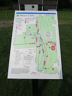
Mono Cliffs Provincial Park
Over the stile and off the road, we crossed an open meadow before entering the main part of Mono Cliffs Provincial Park. The warm spring time weather was welcome as we ventured through an amazing mixed hardwood forest which covered the rolling hills and landscape of the park..JPG)
.JPG)
.JPG)
Side Trails, Ferns, and Cedars
Like many of the Conservation Areas and Provincial Parks along the Bruce Trail, Mono Cliffs is a popular destination that hosts a number of well-maintained pathways. Therefore, with the volunteers and sweeps well behind us, we opted to take a slight detour (which would make our day a bit longer) but which according to the BTC guidebook would give us a chance to view some amazing geology and fauna. As such, we diverted off the main Bruce Trail onto the Spillway Side Trail for a bit of exploration..JPG)
.JPG)
.JPG)


.JPG)
.JPG)
We could happily have spent the entire day investigating the bird nest
boxes that lined the trail, following the pathway that wove through a dense
forest along the Niagara Escarpment, enjoying the fascinating views of the
area’s geology, and taking in the stunning number of unique ferns. Unfortunately, we still had 23 kilometres to
go. Heading north, the Bruce Trail
followed McCarston Lake Trail, taking us to the 1st Line EHS.
.JPG)
.JPG)
.JPG)
Farmlands and Concessions
We walked the length of a concession, which seemed more of a road allowance than roadway, for about 2 kilometers. A huge highlight was spotting a porcupine in the trees above us as we strolled past Victorian brickwork farmhouses. Our time on the roadway made us grateful for the shade of the large coniferous trees growing alongside the backcountry road..JPG)
.JPG)
.JPG)
.JPG)
.JPG)
.JPG)
.JPG)
.JPG)
.JPG)
Boyne Valley Provincial Park
We entered Boyne Valley Provincial Park via a disused road allowance. Boyne Valley is a wonderful provincial park located an hour north of Toronto (by car, much longer by foot!). A number of rivers traverse the park along the Orangeville and Singhampton glacial moraines. The rolling terrain in Boyne Valley includes a mixture of hardwood forests, open fields, and marshlands, making it a wonderful place for bird-watching, nature exploration, and hiking..JPG)
.JPG)
.JPG)
Following the Boyne River
Leaving the Provincial Park behind, we crossed the 1st Line E concession and made our way along the edge of a farmer’s field. Next, we skirted a ravine overlooking the Boyne River and the marshlands below. Our route took us through a colourful forested area known as Walker’s Woods Lookout, from which we could see parts of Mono Cliff Provincial Park – now some 20 kilometres south of us..JPG)
.JPG)
Throughout this stretch, the trail
wove through the local green space before descending on a steep hill toward
Oliver Creek. Thankfully, the BTC has installed a number of boardwalks and
bridges throughout the dense cedar forest and marshy parts of this property, or
our feet would have been very wet.
Overall, tracing the escarpment over the Boyne River we enjoyed the deep
shady valleys, streams, and wooded slopes before arriving at a parking lot just
south of Dufferin Country Rd 17.
Also
according to the BTC website, an International
Friendship Trail is used by the Bruce Trail Conservancy and the World Trails Network to raise awareness
of and support for public trails around the globe. The concept is similar to “twin towns” where
regions across the world partner towards mutual cooperation and publicity. At present, the Bruce Trail has 9 Friendship
Trails along its route, which means that we have already visited 5 of them!
Bibbulmun Track Friendship Trail
As we trekked through this section we met a group of BTC land stewards who were planning the installation of new signs. Being curious, we asked what the signage was set to indicate, and so discovered that recently a nearby section of Bruce Trail had been twinned with the Bibbulman Track in Western Australia. According to the Bruce Trail Conservancy website, this pathway stretches approximately 1000km from Kalamunda in the Perth Hills to the historic town of Albany on the south coast of Australia. In the process, the trail traverses the karri forest and coastal heathlands through some of Australia’s top biodiversity hotspots..JPG)
.JPG)
These include a section of the BTC in Short Hills Provincial Park that is twinned with the Rim of Africa, a section near Waterdown that is matched with Offa's Dyke Trail in England, a piece of the BTC north of Milton that is twinned with the Kythera Hiking Trail in Greece, and a section of Hockley Valley Provincial Park that is connected to the Jejo Olle Trail in South Korea. Perhaps one day we will have a chance to trek some of these partnered trails around the world.
.JPG)
.JPG)
Reflecting on the BTC at Day’s End
Back where we had begun our day at the historic crossroads of Whitfield, we were greeted by volunteers ringing cowbells and cheering us on outside of the quaint abandoned red brick church which was once part of the community of Whitfield. Having hiked approximately 31 kilometres under heavy pack weight, we were glad to have gotten through the day. Our arrival back to Whitfield also meant that we were now more than halfway done the Dufferin Hi-Land Section of the Bruce Trail.
See you on the Trail!
Comments
Post a Comment