Welcome to Our Blog Hiking Ontario's Bruce Trail

Image
Hiking Ontario's Bruce Trail Bruce Trail Hiking Blog The Bruce Trail is one of Canada's most iconic and scenic hiking routes, stretching over 890 kilometres along the Niagara Escarpment in Ontario. As the oldest and longest marked trail in Canada, it offers hikers an unforgettable journey through lush forests, charming villages, and breathtaking views of waterfalls and cliffs. Whether you're an experienced hiker or a beginner, the trail provides a range of accessible sections that highlight the diverse beauty of Southern Ontario’s natural landscapes. With its well-maintained path and rich history, the Bruce Trail is a must-explore destination for outdoor enthusiasts looking to immerse themselves in the heart of nature. Continue reading to learn more about the best sections of the trail, tips for hiking, and what makes this trail a unique Canadian adventure. Over the span of 10 years, we completed the Bruce Trail in a series of day hikes, organized End-to-End events, and one...

Hike 31: Reflecting on the Bruce Trail - Owen Sound to Glen Management Area

Reflecting on the Bruce Trail

Bruce Trail in the Bruce Peninsula

As noted in our last blog entry, Rolling Back the Clock, while we have shared our adventure along the Bruce Trail in geographical order from south to north, the fact is that our final thru-trek on the BTC was actually our first long-distance hike.  From Aug 6-18th, 2014 we trekked from Owen Sound to Tobermory through the Sydenham and Peninsula sections to the Northern Terminus of the Bruce Trail.  A family thru-hike, it was also our first attempt at long-distance trekking.  This meant that we carried our own gear and certainly made a lot of mistakes en route.  With that said, despite the challenges, we were able to successfully complete this little adventure of 241 kilometres.  In the end, our time on the Bruce Trail served as the basis of our future hikes along the BTC, in Spain along the Caminos Frances, Madrid, San Salvador, Primitivo and Fisterra, across France on the Via Podiensis, the length of Portugal on the Rota Vicentina, Caminho Portuguese Central, Coastal, and Espiritual, as well as Newfoundland’s stunning East Coast Trail, and the incomparable Trans Canada Trail from the Atlantic to the Pacific. Our first trek on the Bruce Trail was a learning experience.  It taught us a great deal that we have carried with us as we have continued to explore nature.

Bruce Trail Hike Ontario Canada.
 

The End is the Beginning

 
Setting out, we bought new backpacks that we neither fitted nor tested before arriving on the trail.  We packed extra clothing for every possible situation that we could imagine – no matter how inconceivable.   Not knowing what we would need, or how much we would eat, we packed too much food and far too many supplies.  Beyond all of this, the tent we had and took with us was a 4 person shelter that weighed a staggering 15 lbs.  Walking out our door and onto the Bruce Trail in 2014 would be an experience that would define almost everything that has come since. 
 
Given these circumstances, and our untested selves, and unlike our subsequent adventures along the Bruce Trail detailed over the course of the last 30 blog entries - we make no claim to have hiked every kilometre.  Given that we were in the midst of learning, that we had a younger individual on the trail with us, that there were trail reroutes at the time, and that we needed to leave the path to get to campgrounds and grocery stores, we at times missed small portions or by necessity chose a different route.   In the years that have followed, we have since gone back and completed many of these missed areas, and would fully recommend them to anyone.  The Bruce Peninsula is beautiful and inspiring - though now often very full.
 
And so it was with this mindset and these goals that one evening in August 2014 we stuffed our gear into three massive backpacks, strapped on new hiking boots, took the Gameboy out of the back pocket of our younger relative, and turned off the cell phone.  For the next 10 or so days there would be no need for updates, texts or video games.  We were heading into nature where the connection would be better.
 

The Bruce Trail

 
Thru-hiking the Bruce Trail from Owen Sound to Tobermory left us with few options and lots of questions.  Even beyond the challenges of the trail, we still had to deal with a number of logistical headaches.  How to get to the region?  Where to leave our car? How to get back to our vehicle after our hike?
 
Ultimately, we decided to drive from Toronto to Tobermory, park our car at a friend’s house, and take a regional bus back south to Owen Sound.  Our logic was that once we left Owen Sound, we could only get our car back by walking to Tobermory.  No matter what challenges lay in front of us, we would have to find a way to make it work. 

 
The Greyhound bus dropped us off in Downtown Owen Sound, and for the first time, we lifted our backpacks onto our bodies … and immediately began to wonder if we had overdone it.  My backpack was a hefty 65 lbs, thanks mostly to a 4 person car-camping tent.  Sean’s backpack was 60 lbs, the result of a week’s worth of food for 3 people.  Our younger relative carried his clothes and had a backpack of 15 lbs.  Early on, we had sought to ensure that his focus should be on enjoying the hike and time in nature rather than struggling with a full backpack.  He simply needed to carry each day’s snacks, a couple extra bottles of water, and his clothes for the week.

Bruce Trail Owen Sound Ontario.
 
Dropped off in downtown Owen Sound, we slowly made our way through town to the local campground in Harrison Park for the night.   Our arrival at our camping space was one of the happiest moments of the day, as we were able to take off our backpacks after a mere 3-kilometre walk.  Worried about the weight of our packs, we began to strip out clothing, an extra tarp, and 3 leather books that we had romantically brought with the idea of blissfully writing nightly trail journals.  The clothes and tarp were soon taken back into town and put into a Goodwill bin.  The journals, which the youngest member or our group had only ever seen as “summer homework” were blissfully used as fire starters for the night’s campfire.
 
Harrison Park Owen Sound Ontario.
Camping in Owen Sound.

Having spent the evening camping in Harrison Park we were up early amid the crowded campground.  We made breakfast and slowly got ready for what lay ahead.  In the end, it took us over an hour to pack up and get ready to make our way to our designated starting point of Inglis Falls. 


Bruce Trail Inglis Falls Ontario.

Bruce Trail in the Fog Ontario Hikes.

As we stepped onto the trail the heavens opened, and having packed our rain gear at the bottom of our backpacks, we and all of our gear was soon soaked through.  Even Sean’s attempt to hold our camping tarp over us as we emptied our backpacks, dug out our rain jackets, and repacked our bags during a particularly strong deluge did little to keep things in order or dry.


Inglis Falls along BTC hiking pathway.

Frustrated at our poor start, we nonetheless pushed forward – nervous that if we delayed or stopped so early on it would give way to a flood of self-doubt.  And so, soaked through and struggling under the unreasonable weight of our backpacks, we walked through and out of Harrison Park, following the BTC north from Inglis Falls through West Rocks and Springmont Forest. 


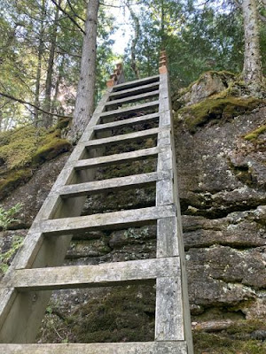
Two hours later we arrived at HWY 21, where I had to step around a tree and cry after the effort required to lower myself down the seven rungs of a wooden ladder.  By the time we had covered this meagre 7 kilometres, I think we were all ready to walk back into town, get a motel room, and go home. 

Bruce Trail Escarpment ladder.
 
My only thought was “don’t think, just keep walking”.  And so I stood back up, pulled my backpack on, and crossed the busy 4-lane highway.
 

Owen Sound Ontario

 
The city of Owen Sound is one of the few larger urban areas we've come to since we hiked out of Hamilton and the GTA many hundreds of kilometres to the south.  It is also the geographical starting point of the peninsula region which will eventually lead us to Tobermory.  The area around Owen Sound was purportedly visited by Samuel de Champlain in 1616.  He met the First Nations peoples who called the region Wadineednon or “beautiful valley”.  Later, this region was the site of the Aboriginal village of Newash, but by the mid-19th century, it had been taken over and settled by Europeans, who referred to the area as Sydenham or Sydenham Bay.  They named it after Charles Thomson, Baron of Sydenham and governor-in-chief of British North America (1838-1841).   In addition, sailors purportedly referred to the region as Owen’s Sound after Captain William Fitzwilliam Owen who had charted the nearby waters in 1815.  At present, the city of Owen Sound is home to the Tom Thompson Art Gallery which focuses on the works of Tommy Thompson and the Group of Seven as well as the Billy Bishop Museum.


Pottawatomi Conservation Area

Pushing northward out of town we entered into the Pottawatomi Conservation Area. There the rainy weather of the morning let up some, allowing us to enjoy our hike without our warm rain gear on.  The Bruce Trail in Pottawatomi almost immediately came to Jones Falls, which was a quaint stepped waterfall alongside the pathway that looked as though it had carved its channel from the limestone of the escarpment.  


Pottawatomi Conservation Area.
Pottawatomi Conservation Area birds.

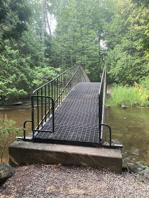
Worried that if we stopped again I would not have the willpower to continue on, we crossed the Potawatomi River over a long metal bridge and continued northward.   There the geology and natural wonders of the Niagara Escarpment were on full display.  At one point, while navigating around huge boulders amidst a gorgeous coniferous forest, we passed a large separation in the escarpment through which we could see the leafy deciduous trees below.
 

Neighbourhood Walking

 
Still following the top ridge of the escarpment, we left Pottawatomi Conservation Area, crossed the busy Derby-Sarawek Townline, and began what would be a 4-kilometer stretch of neighbourhood trekking. Still well within the bounds of Owen Sound – even after 12 plus kilometres of hiking – we began boxing along the edge of subdivisions, down load roadways, and through quiet neighbourhoods.  This long run of pavement and housing gave way to quick and easy hiking, but certainly stood in stark contrast to the forests that we had enjoyed throughout the morning.

 
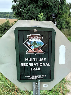
Trekking northward on Range Rd, we came to the end of the pavement and turned onto the Georgian Bluffs Rail Trail – a former CN Rail Line that we would follow to the three-way intersection of Benallen.   This section was a very wide gravel track which wove through the open farmland of the countryside for several kilometres.  Our only real challenge throughout this area was that a group of local ATVers were racing up and down the pathway, leaving little room for anyone (neither us, nor a family cycling the trail).   These motorized vehicles and their operators never slowed down, gave no indication that they had seen anyone on the trail, and gave no notice of passing – they simply covered us in mud as they raced through the puddles beside us.  All and all, this did not feel like a very welcoming beginning to our trek.    Now covered in mud, we continued alongside cow pastures and passed a tall wooden sign indicating the direction for Benallen Junction, Wiarton, and Shallow Lake. 
 

Roadway Trekking

 
Grateful to be off the ATV racetrack, we turned off the rail trail and commenced with our second stretch of roadway trekking for the day – along the Gordon Sutherland Parkway.  This narrow gravel track wove us slowly into the countryside, past farms with iconic, large red barns, and amid fields browning under the heat of the summer.
 
Not paying much attention to our BTC map, only knowing that we had a long stretch of roadway, we ventured on.  As a result, we walked right past a turn in the trail and only noticed our mistake when we arrived at Indian Acres Rd, where we had to figure out where we went wrong and relocate the trail.  Thankfully, we were only a few meters away from where the Bruce Trail also crossed the road, and we were able to pick it back up.  Following a dirt or gravel roadway (that might well have been an unmaintained route, as we could not see how anyone beyond ATVers could drive on it), we pushed on for another two kilometres through exposed fields before coming to a densely wooded area. 


Glen Management Area

 
Walking into the Glen Management Area we were finally off the roadways and ATV racetracks, which we had navigated for nearly 20 kilometres.   Exhausted after more than 6 hours of hiking, we collapsed for our first and only break of the day.  In truth, it had been a huge mistake not to have taken a break earlier, yet with the long road walks through neighbourhoods and along the Gordon Sutherland Parkway, we had no idea where to stop. 
 
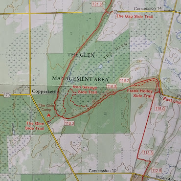
Glen Management Area Bruce Trail Map.

Grateful for the rest break, and sitting in a puddle of pain and self misery, with our backpacks lying in a pile on the side of the pathway, we checked the guidebook.  While ostensibly we were reading about the area, in reality, we were searching for reprieve.  We all knew that our hope of getting to Bass Lake and the campground there was no longer realistic.  Heck, at this point it may not even have been physically possible for the three of us to hike the remaining 15 kilometres to Bass Lake.  We needed to find another option.  Blessedly, a line of red text stood out on our BTC guide maps noting “The Glen Camp”!!!  This spot was an official camping area, it was near a water source, and it was close!  With a mixture of relief and excitement, we decided to change tonight’s destination.  Our goal was now to stumble the 3 or so kilometres between where we were and the official BTC Glen Camping area for the night.

 
After a 30-minute break and several Cliff Bars, we each slowly stood up, slipped our heavy backpacks onto our shoulders, and resolutely marched toward the light at the end of the tunnel – a place just 2 kilometres away.  The Glen Management Area is a region in which the Bruce Trail essentially loops around a large wetland along the top of the escarpment, and so we stumbled along the relatively flat pathway.  Blessedly, the canopy of the forest kept the late afternoon sun off of us, aiding our weary bodies.
 

Grateful Camping, Tired Reflecting

 
A short trek that seemed to stretch forever soon came to an end when we turned off the main BTC pathway and followed the short Glen Side Trail to the primitive campsite.   Once there, we again dropped our backpacks onto the ground and sat down.  Hiking boots and wet shoes were soon stripped off and sandals were taken out to give our feet a chance to dry off and air out. 
 

Sitting there, knowing the day was at its end, none of us wanted to get up to do the necessary chores.  In the end, it was only the mosquitoes in the area that prompted us to get up and set up our tent.   Once assembled, the youngest of us collapsed and was soon asleep, despite it being mid-afternoon.  Envious of him, Sean and I changed out of our soaking wet hiking clothes, hung a line up to dry them out and put our shoes into a puddle of sun in an attempt to burn some of the wetness out of them.  Next, one of us went to get and purify water while the other inflated our thermarest mattresses and took out the night’s camping meals. 

 
An hour later we had enough water collected and ready for dinner and tomorrow’s breakfast.  We boiled water, let our meals rehydrate, and prompted our younger relative to change his clothes, which were sweaty and smelling from the day’s efforts.   Mechanically, we ate our dinners of Veggie Lasagna and were soon headed for bed. 
 
As the day’s efforts came to a close, I admit to being uncertain as to how to feel.  We are certainly excited to have set off on our family trek, we are definitely exhausted from the day’s efforts, but I at least am a little depressed from our lack of progress.  All in all, it was a tough day with hard distances covered by a trio of people who were unused to the weight of backpacks.   It had taken us longer than expected to get to this point, and we were all footsore and soaked from the rain this morning, as well as the rising humidity throughout the rest of the day - but we had gotten a decent part of the Bruce Trail completed and our first day was over!
 
While we should have figured out our destination and plans for tomorrow, we simply didn’t have the energy to focus on more of the Bruce Trail tonight.  Tomorrow’s problems would have to be dealt with tomorrow. 
 
I have never been so grateful to lie down as I was on this night. 

Comments