Exploring the Fort to Fort Trail : Fort Erie to Niagara Falls
Exploring the Fort to Fort Trail
Fort Erie Ontario
If you're a nature enthusiast or a history buff, the Fort to Fort Trail and Niagara Parkway Trail offer one of the most captivating hiking experiences in Canada. Stretching across the Niagara region from Fort Erie to Niagara-on-the-Lake, this 57 km local pathway and section of the Trans Canada Trail (TCT) blends stunning natural beauty with a rich historical backdrop.

As part of the iconic Great Trail, the Fort to Fort Trail—also known as the Niagara Parkway Recreation Trail and the Freedom Trail—offers hikers an unforgettable journey through both the past and present.


Exploring Historic Fort Erie
Given that we had set out on what was at times termed the ‘Fort to Fort Trail’ we felt that it was appropriate to begin with a tour of the fort itself. Old Fort Erie, a British fortification dating back to the War of 1812, stands as a testament to the region's military past. Though the present site is the fourth fortification on this location, the fort’s pentagonal layout and earthworks nonetheless offer a glimpse into the area's strategic importance. A visit to the fort provided us a chance to explore barracks, guardrooms, and a memorial to those who fought and died during the 1814 siege by American troops in the War of 1812.


Trekking the Fort to Fort Trail


The Freedom Trail and Black Canadian History


The Niagara Parkway and Fort to Fort Trails are more than just a hiking pathway or scenic route; they are also a route of profound cultural importance. Key to this is the history related to the Freedom Trail which is designed and dedicated to furthering people’s understanding of the role the area played in the Underground Railroad and Black Canadian History. In particular, it provides a means through which to explore the substantial contributions that escaped slaves, Black British, Black Loyalists, and Black Canadians made to the region throughout its history.


Soon after Freedom Park, we noticed a plaque between two buildings noting that the cheesemaker James L. Kraft was educated and had worked locally. Kraft, whose name is recognizable from grocery stores across Canada, would later go on to open a cheese factory and develop a new revolutionary pasteurization process which allowed cheeses to be shipped over long distances without spoiling. Although his factory was based in Buffalo, his roots and the early foundations of his career trace back to Niagara, a testament to the area's influence on the food industry.

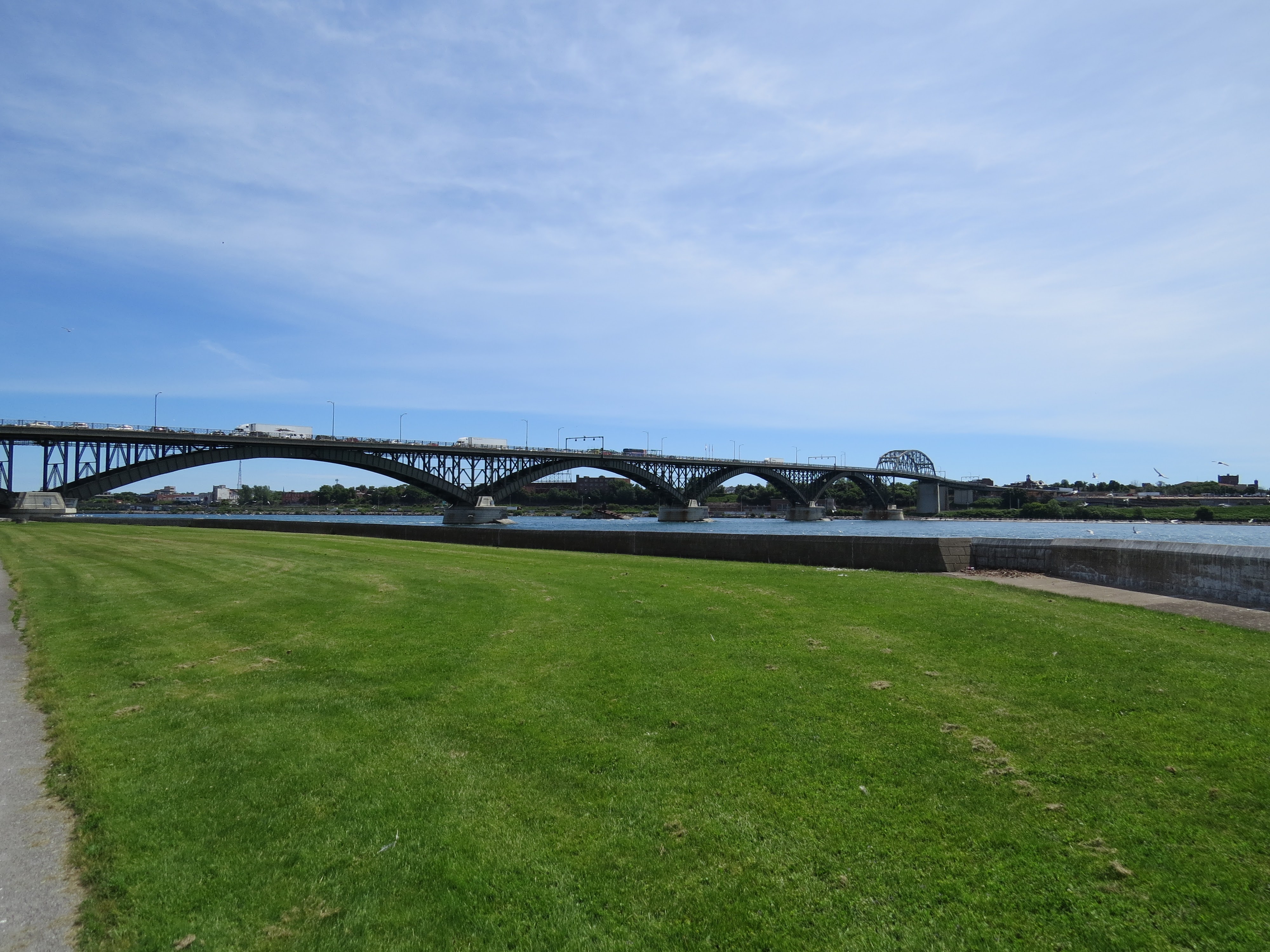
Our route continued northward, and we again crossed under a bridge linking our two nations. Not long after, the trail crossed under a steel-beamed train bridge connecting Canada and the United States, a reminder of how connected our two nations are.

Continuing our hike, the next site we came
across was Bertie Hall, a stunning
red-brick mansion with towering white columns. This historic building, once a
warehouse in the 1800s, also served as a “safe house” for escaping slaves
seeking freedom in Canada. Despite the abolition of slavery in Canada, American
bounty hunters frequently searched the region in an attempt to capture escaped
individuals. The metalwork symbol of a fleeing slave on-site is a moving
tribute to the courage of those who sought refuge here.


Indeed, it was while seeking refuge from the
sun under the trees on the shoreline of the Niagara River that we came across a
pair of beautiful glowing white Great Egrets with their telltale yellow beaks
and black legs! Here we found one of the majestic birds wading in the shallow
water a few feet off the shore, while another sat in the tree above us!


Given the heat, we soon moved off the main trail and began to trek on the periodically treed green space paralleling the side of the road.


With the day increasingly getting warmer we soon arrived at Miller’s Bay where we took the opportunity to rest at one of the picnic benches. Here, we found an unassuming plaque that tells the story of ‘Little Africa,’ a community of Black Canadians in the region in the 1840s. These early settlers, many of whom were Black Loyalists, significantly contributed to local industries such as lumber, railways, and shipbuilding. This lesser-known chapter of Niagara’s history is a powerful reminder of the diverse contributions that shaped the region.


Venturing onward, we followed the Niagara
Parkway road which paralleled the shore. Crossing over the Black Creek we
ventured past the Niagara Christian Collegiate and Riverside Community Church,
as well as the Willoughby Historical Museum. Having circumnavigated the
boundaries of the Legends on the Niagara Golf Course, given the meandering
nature of the waterway and paralleling trail, we could now see Niagara Falls in
the distance!


Heartened that the day’s destination was in
site we pushed on. Across from the
Niagara River, we could see Navy Island National Historical Site.
From 1761 to 1764 this island was a British shipyard building the first British
vessels to sail the upper Great Lakes. It was an essential outpost during
the Pontiac uprising from 1763-1764, and briefly served as the declared seat of
the Republic of Canada for William Lyon Mackenzie’s exiled government during
the Rebellion of 1837.
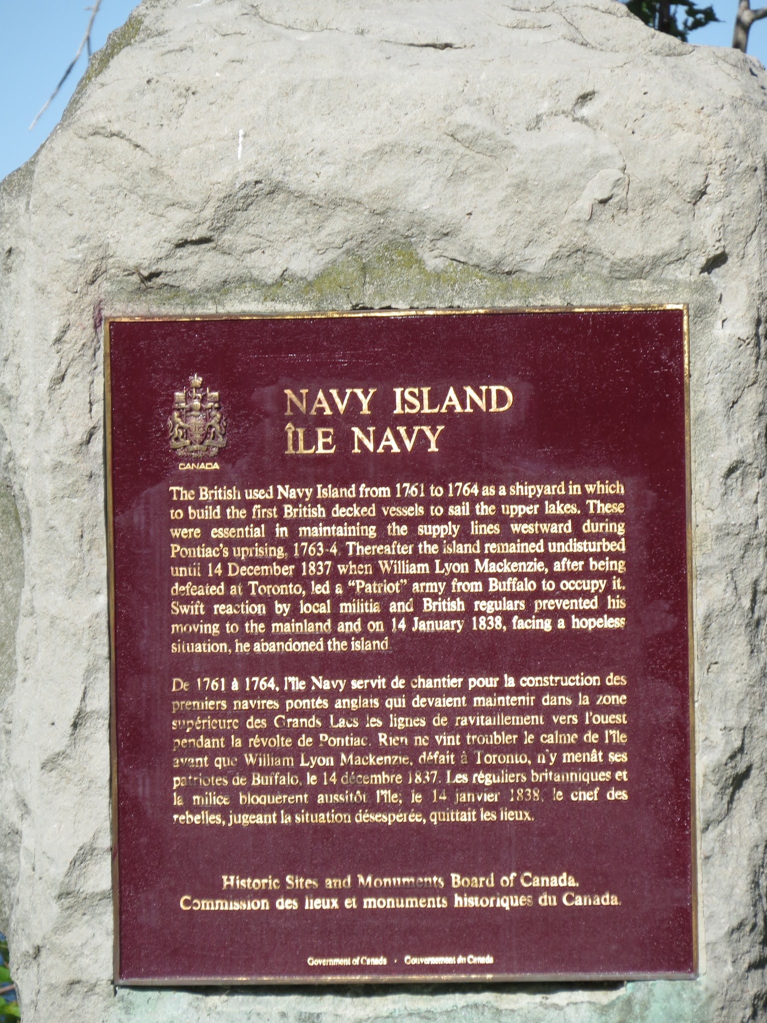
Years later, following the Second World War,
Navy Island, was considered as a viable location for the headquarters of the
United Nations on a neutral territory. Today it is an uninhabited
forested island and an archaeological site managed by Parks Canada.


Rounding the Legends of Niagara Golf Course
we next arrived at the Chippawa Battlefield National Historic Site, marked by a small stone obelisk and
historic plaque. This site commemorates the Battle of Chippawa, which took
place on July 5th, 1814, during the War of 1812. Here, American forces defeated
British troops but would later be defeated in the Battle of Lundy’s Lane before
withdrawing to Fort Erie.

Natural Beauty and Wildlife Along the Niagara River

Given the heat of the day, we took a few moments to rest in the shade on the park benches. Never had sitting felt so good. As it turns out, the Niagara Parkway Trail is a haven for birdwatching and wildlife observation. We have seen a number of species already today including Great Egrets, Double-crested Cormorants, and a variety of waterfowl. The Dufferin Islands Nature Area provided tons of opportunities to observe the abundant birdlife in the area.


Niagara Falls and National Parks

As
the trail moved along the banks of the river way, we soon found ourselves being
covered in a mist which descended throughout the region. Soon after we
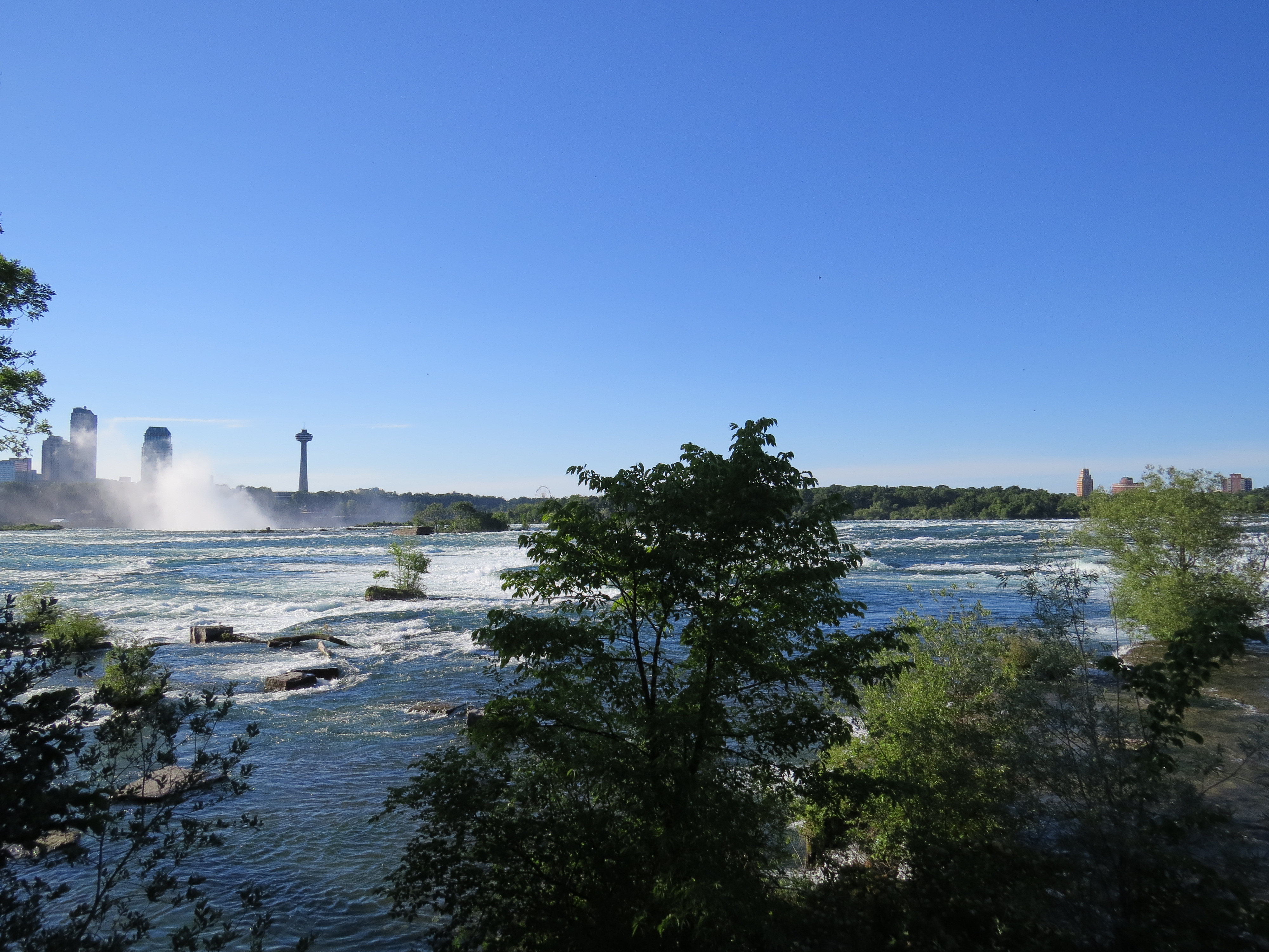
arrived at the world-renowned Niagara Falls.
The majestic Horseshoe Falls, part of the three waterfalls that make up
Niagara Falls, is an awe-inspiring sight. Interestingly Niagara Falls is
actually composed of a series of three waterfalls including Horseshoe Falls,
American Falls, and the Bridal Veil Falls which span the Canada-U.S. border and
the Niagara River.

The
Canadian Falls, or the Horseshoe Falls, spans between the Canadian shoreline at
Table Rock and Goat Island on the American side. As such the iconic image of Niagara Falls is
primarily in Canada according to the international border detailed in 1819 in
the Treaty of Ghent. This impressive waterfall is estimated to be
about 170 ft (52 m) tall and 2700 ft (820 m) wide. However, these numbers
are gradually changing as the falls slowly move owing to erosion.

Information
at the Table Rock Information Centre estimated that about 90% of the Niagara River
flows over Horseshoe Falls, while the remaining 10% flows over the American and
Bridal Veil Falls. While Niagara Falls is not the largest waterfall
in the world, it is the biggest in terms of the sheer volume of water which
flows over it which is estimated to be about 750,000 gallons of water every
second.


We
took our time enjoying Niagara Falls from the vantage point of Table Rock. The information center located here is named for the flat
rock which was previously on this site and which jutted out into the
water. This site is also important as it was privately owned until 1885
and included high fences and buildings which blocked the view of the falls to
anyone who refused to pay for the privilege of seeing it. In response,
the Niagara Parks Commission was established in 1888 as part of an
international effort to preserve the natural scenery of the region, as well as
to allow access for visitors to view the falls.


Having finally arrived at our destination for the day, we took the opportunity to cool off by taking a Journey Behind the Falls.


As you stand at the edge of Niagara Falls, you’re not just witnessing the power of nature—you’re experiencing a significant part of North America’s cultural and natural heritage. In the early to mid-nineteenth century, the area around Niagara Falls was viewed by travellers, European tourists, and travel publications as disastrously privatized and overly commercialized - to the point of undermining the natural beauty of the region. In this way, the Niagara region quickly became a symbol of tacky over-development and privatization from which support for public protected spaces and National Parks arose across the world. As a result, similar places of natural wonder were held in trust for public use and enjoyment for all time rather than as the property of the few. The goal of these public spaces and National Parks was to preserve the splendour of a site by preventing the same thing happening to areas of natural beauty and significance so that they continued to exist “for the benefit and enjoyment of the people” for all time.


Maid of the Mist and Skylon Tower
Beyond
the falls as we walked along the gorge we could also see the iconic Maid of the Mist boat tours down below, crowded with people as they venture
near the base of the powerful Falls thundering overhead! In the past, we
have ventured on one of these amazing tours. Today, however, we simply enjoyed
our time throughout this stretch, relaxing in the shade and partaking of an ice
cream (or two) to celebrate the completion of our first day’s hike.


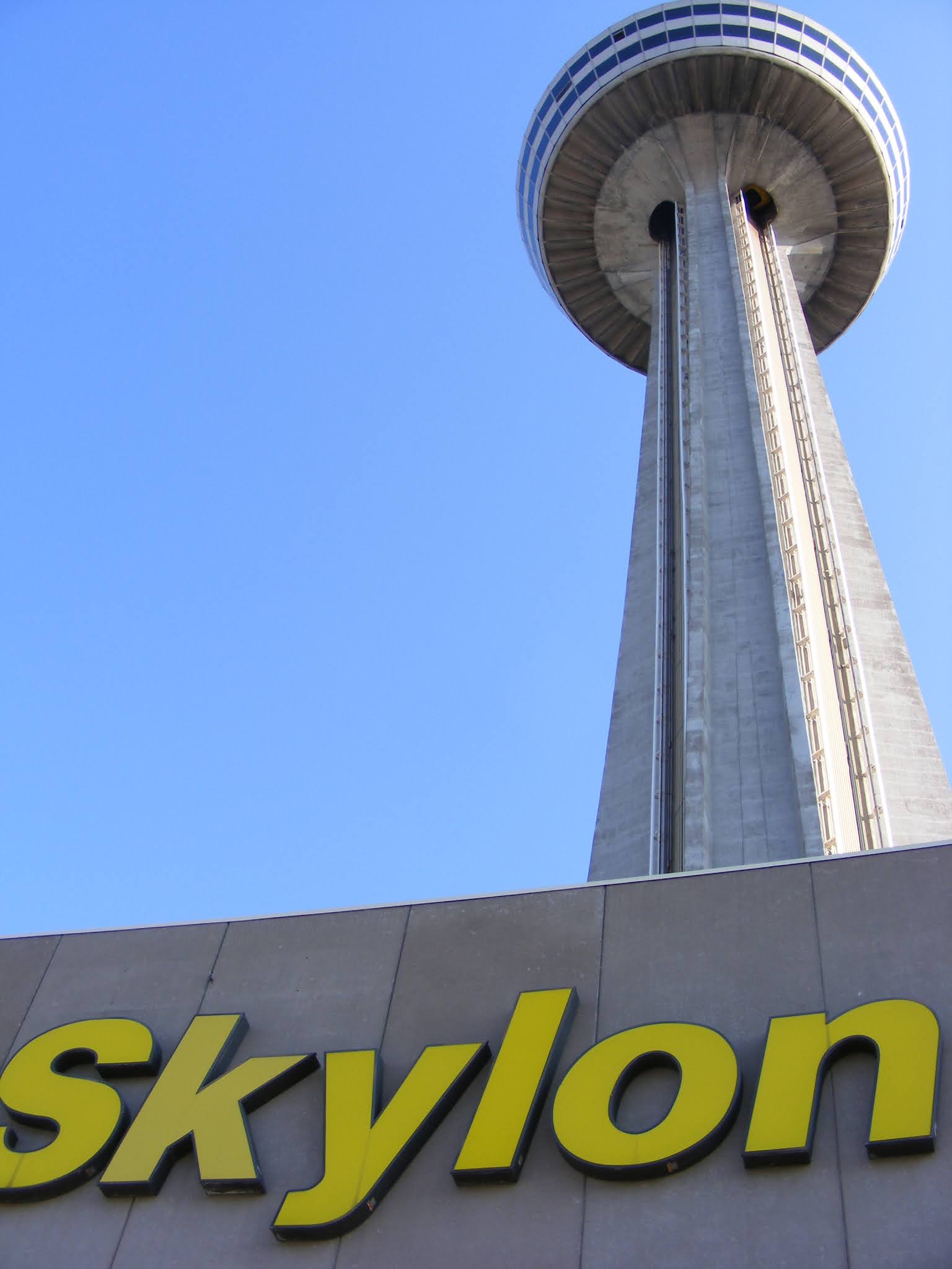
Departing
from the Fort to Fort and Niagara Recreational Trail for the day, we wandered
into town to eat and visit the Skylon
Tower which would allow us to get a view of the Falls from above!


While amazing, the fact remains that walking into Niagara Falls and Clifton Hills after a day on the trail into the hustle and bustle of the vibrant tourist district we were overwhelmed. For two exhausted hikers, the flashing lights, video screens, and music on the streets were a bit much for two exhausted hikers.
Reflecting on our Hike Through Niagara
Our hike along the Fort to Fort and Niagara
Parkway Trails was an unforgettable experience, blending history, culture, and
natural beauty. From Imperial forts and Black Canadian History to the peaceful
birdwatching spots, and finally to Niagara Falls, this trail offers
something for everyone.


With our day coming to an end, and our energy drained, we ventured to the nearby KOA campground for the evening, set up camp, and rested for the night in preparation for continuing on the next day to Fort Erie.
To read more about Black Canadian History in the Niagara Region check out this article by : EH CANADA TRAVEL.
See you on the Trail!
Comments
Post a Comment