Hiking the Bruce Trail and Niagara Escarpment
Hiking the Bruce Trail and Niagara Escarpment
Bruce Trail End-to-End Trek
The Bruce Trail is one of Ontario’s oldest, longest and most popular pathways. When we began trekking it in 2014 it extended a distance of more than 850 km from end to end, along with more than 400 km in side trails available to be explored. Much of its route from Queenston Heights near Niagara Falls in the south through to the town of Tobermory situated at the tip of the Bruce Peninsula in the north follows along the Niagara Escarpment.

En route, the Bruce Trail weaves along a combination of local pathways, and forested trails, through urban green spaces and regional parks. It meanders through dense urban centers, across rural farmlands, and down country lanes as well as across private property and through conservation areas and Park’s Canada sites. At times the trail crosses subdivisions, vineyards, quarries, and ventures past awe-inspiring waterfalls. It visits sites of geological and ecological significance, places of historical importance, and regions of stunning natural beauty.


Among the natural wonders which can be found along the pathway are over 50 species of fern, 40 species of orchid, 36 species of reptile and amphibian, 53 species of mammals, and more than 300 species of birds! The Bruce Trail lands are also home to a wide range of wildlife including red foxes, white-tailed deer, porcupines, and the endangered Massasauga Rattlesnake!

History of the Bruce Trail
The trail system is named after the Bruce Peninsula where the northern end of the path is located. The idea for creating the Bruce Trail arose in the late 1950s when Ray Lowes and artist Robert Bateman began to discuss their vision for a hiking system that would traverse the length of the Niagara Escarpment during a meeting of the Federation of Ontario Naturalists, now Ontario Nature. The first meeting of the Bruce Trail Committee took place on September 23rd, 1960 and was attended by Ray Lowes, Philip Gosling, Norman Pearson, and Robert McLaren. In the coming few years Philip Gosling assisted by dedicated volunteers, began to visit landowners and towns along the proposed route, going at times from door to door to convince people of the importance of regional conservation and the need for the establishment of a trail system.

The Bruce Trail Association was incorporated in Ontario on March 13, 1963 with a membership of approximately 200 individuals. The first guidebook was published in 1965 by Dr. Aubrey Diem, an assistant professor of Geography at the University of Waterloo, detailing the passage of the trail in development which then covered a distance of approx. 460 km. Soon after, in 1967 the cairn at the trail’s northern terminus in Tobermory Ontario was unveiled to coincide with Canada’s Centennial celebrations!

During this period, the regional clubs were also established along the length of the trail with each organization responsible for a specific geographic region, path construction, regular maintenance, and regional conservation. These nine clubs, still exist today as the familiar sections of the Bruce Trail are:
Niagara Club: Queeston Heights to Beamsville
Iroquoia Club: Beamsville to Milton
Toronto Club: Milton to Cheltenham
Caledon Hills Club: Cheltenham to Mono Centre
Dufferin Hi-Land Club: Mono Centre to Lavender
Blue Mountains Club: Lavender to Craigleith
Beaver Valley Club: Craigleith to Blantyre
Sydenham Club: Blantyre to Wiarton
Peninsula Club: Wiarton to Tobermory

On February 8th, 1990 the Niagara Escarpment was designated a World Biosphere Reserve by UNESCO which means that it is an area which has or which is striving to balance the conservation of natural significant ecosystems with regional development. This designation is one of the main reasons that the Bruce Trail evolved into the Bruce Trail Conservancy which is focused on conserving and protecting the green corridor and surrounding lands which the trail follows along the Niagara Escarpment. This role as a conservation organization is essential since the Bruce Trail crosses through some of the most populated centers in Ontario including St. Catharines, Hamilton, Burlington, Milton, the eastern sections of the Greater Toronto Area, as well as Collingwood, Owen Sound, Wiarton, and Tobermory with more than seven million people living along the main pathway.

Waymarking on the Bruce Trail
In general, the pathways are easily followed throughout the majority of the Bruce Trail system. The main path is marked with white blazes on trees, fence posts, telephone or electricity poles, etc, and are placed within view of one another.
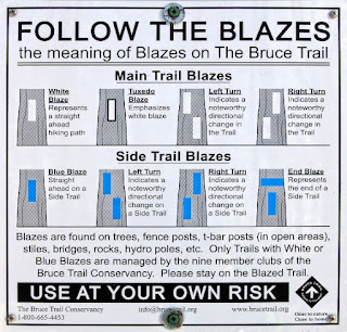
In meandering areas of the trail, blazes are more frequent with several being visible at the same time to help hikers along, Turns are indicated with double blazes, with one above the other, with the upper blaze offset in the direction the trail is turning.


In contrast to the white indicators of the main pathway, side trails along the Bruce system are marked in both blue and yellow blazes.

Comments
Post a Comment