Balance in Nature on the Bruce Trail : Tiffany Falls to Waterdown
Balance in Nature on the Bruce Trail
BTC Iroquoia Section, Dundas Valley Conservation Area
For this hike, we tried something a little different. The starting point was at Tiffany Falls just south of Dundas Valley Conservation Area, on the main trail. However, today we had decided to venture 4 km down the Webster’s Falls Side Trail to explore Tews Falls, and then continue onto Waterdown Village stopping when we reached the Smokey Hollow Side Trail.
When we started the day off we were the only ones in the Tiffany Falls parking lot. We began with the short (420m) walk down the Tiffany Falls Access Trail, and were awarded with a beautiful view of water cascading down the escarpment in the morning light. The first time Sean, Saryon, and I visited these falls it was winter and the falls were frozen solid. At that time there was a group of climbers just finishing their descent of the frozen falls. It was interesting to see the falls in summer with water flowing.

The bed of this waterfall was much smoother than others we had encountered so far and was covered with a smoothing layer of algae, leading us to speculate that the water leading into the falls might be, or might have been at one time, more acidic than that in other rivers. The light was beautiful as the sun rose above the edge of the escarpment, but at 9 AM it was already getting uncomfortably hot and humid.

From the Tiffany Falls parking lot, we crossed over Wilson St. E and began heading west on the main trail, through a nice section of Carolinian forest. Although the trail was threading through an urban area, not too far from a relatively busy road, it still had a secluded feel.


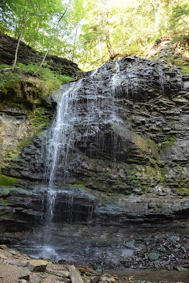
After a kilometre or so we crossed Old Dundas Rd, and almost immediately found ourselves at Sherman Falls. Although we had looked at the maps before setting out, somehow none of us had noticed Sherman Falls, so it came as a pleasant surprise.


Sherman Falls is a 17 m high waterfall fed by Ancaster Creek, and we could see bands of red in the escarpment near the base, although less of the light green that was visible near Devil's Punchbowl. Despite the heat and lack of rain we have been experiencing during the last 2 weeks there was a fair amount of water coming over the falls, making a beautiful pattern.
Sherman Falls is a relaxing site and we took advantage of our time here to photograph the area and enjoy the landscape. Yet even here amid this natural wonder, there were indicators of development and encroachment. Signs dotted the area noting it as personal and private property. In addition to this, sadly, someone has built a massive viewing platform on top of the escarpment to one side of the falls – presumably to watch the waterfalls. As a result, a number of broken beer bottles and wine glasses were scattered at the base of the platform's structure creating a glassy warning against entering the posted private property throughout the valley. An unfortunate “addition” to the beauty of the area.


After climbing the escarpment the trail entered Dundas Conservation Area. Somewhere near the southern entrance to the conservation area, we passed an iron bell, mounted on a concrete platform, near ground level. The bell was missing its clanger, and underneath was a plaque with the thought-provoking inscription "Where there is no vision, the People Perish", put there by natural resource managers. The sight was intriguing and left us wondering what the back story was. Unfortunately, there was no explanation for the bell at the site, in the BTC Guidebook, or online, and so the mystery remains for us.


As the trail continued through Dundas Conservation Area, following the main trail loop, it passed through open fields full of shrubby, wet, low-land patches, and forested areas with some very large old trees, including a lot of hemlock along the banks of river valleys. Trekking through Dundas C.A. is amazing given the density of the forest around the trail and the combination of rocky overhands and gentle waterways.
Monarch Trail
As we set off through the conservation area the Bruce Trail followed the route of the Monarch Trail. The pathway was mostly wide and flat, with a gravel surface, and as we got further into the park we encountered many other people, walking with and without dogs, jogging, bike riding, and horseback riding. As we passed a group of three on horseback they stopped to let the horses drink from a small stream. We stopped frequently as well, making use of the many benches provided in the park, as the heat was getting truly oppressive by this point.


Proceeding through Dundas, the trail rose and fell gently with the landscape as well as crossing over a number of streams. Thankfully given the summer heat, the trail generally remained under a tree canopy which was a welcome relief from hiking down the roadway.
When we reached Canterbury Falls, we had a moment of confusion. On our Bruce Trail maps it looks like the main trail goes right past the falls, yet on the ground it seemed that in order to see the falls, we would have had to take a side trail. Given our hope to Waterdown today, in the end, we decided against doing the side trail and continued on along the main trail a little disappointed.

After passing the parking lot at Lions Club Rd. the trail wound around to the beautiful Hermitage building. We soon discovered that the romantic-looking ruins we saw last time we passed through had been restored to a new-looking facade. It seems the old structure had begun to collapse, and was both deteriorating at an accelerating pace and becoming a safety hazard. The new facade retained the elements of three of the original walls, but the old escarpment stone used to build the original was replaced by larger, square stones, and the foundations and window sills had all been replaced. The foundations of several other buildings remained, and the pathways had been constructed between them, marked off with flagged ropes and interspersed with a new lawn.

Train Stations and the Hermitage
The original Hermitage was built in 1855 by Scotsman George Leith and later destroyed by fire. Although the new structure looks nice and is undoubtedly serves as a nice backdrop for wedding photos, we found that the character of the original building site had been transformed. The whole thing seemed to be a good example of the debate that must surround many restoration projects asking how to keep the spirit of the original while moving forward.

Past the Hermitage, the trail headed down a slope and through more wooded areas. We crossed Sulphur Creek by way of a small wooden bridge, which provided a nice view of a small private waterfall. There was a small lookout at the top of the escarpment to view the waterfall from, which was also private property. The trail followed the creek for a while, before climbing slightly again and emerging onto the grassy opening that surrounded the Dundas Valley Trail Centre.


The central building in the meadows looks like a Victorian train station and is located at the side of the railway tracks, but there was in fact never a station at this spot. Now the building houses a snack bar and a small nature centre/museum. We enjoyed an ice cream from the snack bar and took a few minutes respite from the heat while checking out the train cars at this site, before heading out to refill our water bottles at the tap outside.


Intersections of History and Trails
Central railway station sits at the centre of the trail network within Dundas Valley including the Trans Canada Trail, Brock 1812 Route and Hamilton to Brantford Rail Trail. Having already spent time on the Brock 1812 pathway in Queenston and St. Catharines we were familiar with its route. However, despite repeatedly seeing the signs for the Trans Canada Trail we took the time to look it up on Sonya’s phone. Apparently, the spur of the national trail that we were now standing on would lead hikers more than 600 km from Hamilton to Brantford, into Southwestern Ontario to Windsor.


As we stood there looking up the TCT on Sonya’s phone we were stunned to see that even some of the spurs on the national trail were larger than the entirety of the Bruce Trail or the famous Camino de Santiago. The immensity of such a pathway seemed staggering to a group who was trying to find enough time to squeeze in an 800 km pathway 25 km at a time!


Relaxed and ready to continue on we gathered ourselves back up, tightened the straps on our backpacks and, following the BTC, headed back into the woods, past a small camping site for through-hikers on the Bruce trail.


Roadways and Hayfields
Eventually, the pathway crossed Governor's Rd, one of Ontario’s first roadways. Along this country road, we began to climb a long hill between two hay fields, which had recently been mowed. The drying hay smelled good, and there was a slight breeze near the top of the hill, for which we were most grateful on such a warm day.


At this point, the Bruce Trail was merged with the McCormack Trail, which also forms a loop within the Dundas CA system. Here we were passed by many people out jogging - some of whom seemed to be doing laps around us! A lot of the pathway throughout this section was in more open grassy habitat, which was pretty, but very hot in the open sun. At one point the Bruce Trail turned east and began following along a rail line. As we struggled along through the heat, two trains passed us nearby, the first being a freight train and the other a VIA Rail passenger train. Although the tracks were slightly above the trail, and they were shielded from view by trees and shrubs, the passing trains seemed to create a small breeze that our bodies wanted to bathe in.


As we continued along the tracks we also passed by several tunnels. These tunnels were built of brick and passed below the tracks, and many of them were exuding cold air. It felt like natural air conditioning, and stopped more than once to take a break in front of the cooling tunnels.


In this stretch, the vegetation changed from treed to more scrubby and bushy. Farther along we passed through a stand of tall trees that had been almost completely defoliated by some leaf-eating insect, and soon afterwards we unexpectedly saw a relatively new-looking subdivision to our right which could be accessed by the Davidson Boulevard Side Trail. Soon afterwards we found ourselves passing beside the Dundas Golf and Country Club. Here despite the heat, there were quite a few players on the green, and once or twice we heard "fore" being yelled but thankfully no golf balls came our way.
Looking southeast as we passed the golf course, we had a good view of the escarpment above the 403 and we could see it stretching back towards Hamilton and Grimsby to the south of us. Leaving the forest behind we were soon traversing the golf course parking lot and trekking down Woodley’s Ln.


This paved lane-way intersected with King St. West (Hwy 8) near the trail tracks, and there followed a somewhat uncomfortable scramble along the curve of the roadway and down into the town of Dundas. There is a sidewalk on this road, but it is very narrow and directly adjacent to the roadway, which is also narrow, winding, and busy. As King St. turned the corner into the town we passed an old school that had been converted into loft condos – yet another part of the past being transformed by modernity.
Royal Botanical Gardens and Important Bird Areas
The town of Dundas was originally settled in the late eighteenth century and was known as Coote’s Paradise after Captain Thomas Coote, a regional hunter. By 1800 the region became known as Dundas Mills receiving its new name after its location location at the eastern end of Dundas Street, now King’s Highway. Dundas was soon part of the industrial development of Hamilton when in 1837 Desjardins Canada linked the town to Lake Ontario making it an important industrial region in the 19th century. This same area is now known as the Royal Botanical Garden’s Cootes Paradise and is a wonderful area to visit as well as an Important Birding Area (IBA). Here species such as Bald Eagles, Broadwing Hawks, Rose-breasted Grosbeaks, and Chimney Swifts as well as countless migratory birds and waterfowl have been sighted!
The next section of the trail wound its way along the sidewalks of the town of Dundas, through old, well-to-do neighbourhoods with a lot of gorgeous landscaping. As we turned up Brock St we looked up, and way up above us we could see Dundas Peak, with lots of little tiny-looking people on it. It was a really neat feeling to see where we would end up in a few hours, but it was so hot out (just over 42 degrees), that it seemed a little daunting at the same time. As we continued along Melville St., we passed the St. James Anglican Church, which was very interesting, and farther on we passed the large Roman Catholic church of St. Augustine, which had a large stained glass window. While the neighbourhood was interesting, the paved surface was very hot in the sun.

Finally, the trail turned and headed north, up a steep climb up the side of the exposed Sydenham Rd., though given the busy roadway nearby we were grateful for the sidewalk available to us and focused on taking things one step at a time. Thankfully, not too far up the hill we found the Webster's Falls Side Trail and ducked off into the woods for some shade and a reprieve from all of the road walking. We got off to a bit of a false start when continued straight along a grassy trail that ran into the subdivision instead of following the blazes under the railway tracks and up the hill. We soon discovered our mistake, backtracked, and then began the steep climb again. At the top of the first switchback, there was a wonderful little breeze and a great view out over Dundas.


Dundas Peak
We then continued back west, following the train tracks. It seemed like the trail was following an older rail bed in this section, as the old railway ties protruded slightly from the path in places and old rail spikes could be seen scattered about, like the spine of an old, half-buried creature. Somewhere in this section we again managed to lose our way, when we followed a blue arrow provided by the Spencer Gorge Conservation Area, thinking it was split in the blue side trail. We followed the train tracks for a bit before realizing our mistake and then backtracked again. I think the heat was affecting our judgment.


When we got back to the place where we had gone wrong we again were in for a steep climb, but this time it brought us to the top of the escarpment. There was quite a breeze and we could see for miles. The trail up there was still a narrow footpath running under a tree canopy, but we encountered more hikers than we had since leaving the Dundas Conservation Area.


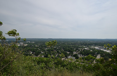
After a short hike along the top edge of the escarpment, we came to Dundas Peak. The view from there was incredible - we could see a huge section of the escarpment that we had hiked, as well as most of the areas we had hiked and gotten lost in earlier in the day. We stopped there for a few minutes to enjoy the view, but there must have been about 30 other people at the peak. Some of them were enjoying the view, or taking photos, but quite a few were texting, or standing with their backs to the view. There was also a LOT of garbage dropped all over the lookout, and the stone wall that is supposed to provide protection from drops was covered with graffiti. In a way, that was kind of sad.


Canadian Olympians and Clara Hughes
Several marched past carrying coolers filled with beer, tossing empty bottles onto the side of the trail. While others were coated in strong cologne or perfume and wore very little clothing despite the blazing sun. In any event, when we had threaded our way through the stream of people to Tews Falls, we saw that it didn't actually have any water flowing over it. It is a beautiful basin, and very beautiful when it has water, but it was simply too hot and dry.


After admiring the waterfalls we headed back to the main trail of the BTC to continue on. Rejoining the main trail on Sydenham St. we resumed our trek northward again climbing up the Niagara Escarpment along the side of Sydenham Rd. One of the few road treks in this section of the Bruce Trail, it was nonetheless a long exposed stretch as cars raced past nearby their engines screaming in protest at the climb. When we arrived back on the top of the escarpment walking into a small area off the side of the roadway we discovered that aside from being a pull-off for Bruce Trail hikers, the spot was also a viewing plateau named "Clara's Climb" after the Canadian Olympian Clara Hughes who used the regional roadways to prepare for competition.


Prior to turning on Romar Dr. which included a nice neighbourhood subdivision where we were soon joined by an inquisitive cat who would stalk us for several minutes as we returned to the main trail and entered Rock Chapel – part of the Royal Botanical Gardens. Royal Botanical Gardens was conceived in the 1920s and initially established in the 1930s. Today RBG is comprised of 2422 acres including the shorelines of Lake Ontario, coastal wetlands and parts of the Niagara Escarpment and serves to protect over 1100 species of plants including endangered species and trees. The lands and waterways are designated as Important Amphibian and Reptile Areas as well as Important Bird Areas (IBA). The regions protected by RBG are considered some of the most significant wildlife and native plant areas in Canada and include one of the best birding-watching areas in Canada at Cootes Paradise / Dundas Marsh. Interestingly, the RBG pathways throughout its properties including those in Rock Chapel are part of the original founding of the Bruce Trail.


Now off the roadway and back on the pathway we were soon cooled by the dense foliage of the escarpment forest again. The sole exception was when the trail soon brought us to a clearing made for the power lines and hydro corridor which ran through the region. From this point, we could see across to the other side of Dundas Valley which the corridor spanned. There are times it is stunning to realize how much development has taken place and how much influence we have and can have on natural regions.

Continuing on we soon came across a quaint stone bridge over a dried-out river bed – a reflection of the strength of the heat throughout the summer in the region. Throughout this section, the Bruce trail wove amid a number of other hiking paths including side trails, Conservation Area pathways, and Escarpment property trails. As a result, we again had to constantly watch that we were following the white blazes of the Bruce trail or risk going off course.

En route, we came across what seemed to be an old park pavilion and cookhouse. Though both had a fair amount of graffiti they nonetheless were unique and had a great deal of character. In Rock Chapel, we were fascinated by a new type of trail signage noting that drone usage is prohibited – a stunning reflection of our times.

The trail soon ventured along Chapel Rd. around a gorge carved into the escarpment to the top of Borer's Falls, a 15 m high waterfall fed by Borer’s Creek. Unfortunately, much like Tews Falls, there was very little water today and so rather than enjoying a waterfall, we contented ourselves with a view of the escarpment and surrounding region. Yet all was not lost, while visiting the region of Borer’s Falls we came across a geocache in a nearby tree which brought Sonya's total found to 450!
We continued our hike along Borer's Creek prior to descending the face of the escarpment along a long series of wooden stairs into a forest valley below as we headed towards Valley Rd.


From these stairs, hikers can closely examine the varying geological layers which compose the escarpment. Interestingly much of this stretch of the trail reminded us of the Eramosa Karst Conservation Area in Hamilton.
Continuing on we crossed Hopkins Creek on a bridge and followed the pathway as it wove through the forest leading us to RBG’s Berry Tract – a piece of land set aside for conservation in 1965 which made us feel isolated from the sprawling development of the region.


Navigating Roadways and Highways
After a brief trek alongside Patterson Road, we came to Old Guelph Rd or HWY 6 only to discover a concrete tunnel which allowed the trail to cross under the roadway. Though not as interesting as the Screaming Tunnel near Queenston Heights we were nonetheless grateful that we did not have actually cross the highway. This structure again made us wonder how the BTC had historically dealt with such matters. According to online sources the tunnel had a construction date of 2007, so one can only imagine that hikers before that time needed to navigate the very busy traffic of HWY 6 – a horrifying thought, that made us all the more grateful for the tunnel route.


The Bruce Trail soon brought us back to forest cover and we came across an old foundation and ruins of a stone house. The ruins, though covered with graffiti and the basis for a number of campfire pits are nonetheless beautiful – making us wonder about the history of the site.


Unfortunately, there were no signs or mention of the structure on the trail. According to some authors and online historians, these structures are the remains of a historical maple sugar shack which was destroyed in the 1970s. In the end, we spent about half an hour relaxing and enjoying a snack at the stone structure before heading off on the final leg of our day's journey.


Clappson's Corners


Yet despite the evident urbanization of the region the BTC had kept us in a small oak and maple forest – known as Clappison Woods - where, as we crossed over a wooden bridge, we found dozens of frogs and a few garter snakes! Nature’s ability to persevere is amazing!


Offa's Dyke Friendship Trail
Soon afterwards we would encounter an active railway crossing and a clearing in the forest which hiking across felt like moving in a blast forge pushing us to again rest to enjoy some cool water. Entering into Waterdown Woods Nature Reserve the BTC followed Grindstone Creek bringing us to the Offa's Dyke International Friendship Trail – a pathway tied to the Bruce Trail!


Grindstone Creek itself was fascinating to walk along as the stream alternated between being a thin trickle and becoming a rushing torrent flowing over chunks of fallen escarpment. Eventually and gradually the Bruce Trail began to climb back out of the valley we had explored and pulled away from the stream’s edge.


Waterdown Ontario
By late afternoon we walked into the village of Waterdown and were both exhausted as well as done for the day. As a final treat here we were given a final view of Lake Ontario which made us all that much more aware of the change in our direction and perspective since setting out from Queenston Heights so many hikes ago.
"Where there is no vision, the People Perish"
I am often left amazed by nature, and its ability to bring peace and calm, and I love how time in the outdoors can be so inspiring. However, the fact is that after this hike I am left being conflicted about people in the outdoors. As an advocate who promotes getting all people connected to nature, increasing accessibility to green spaces, and getting youth onto trails I clearly believe that we are all better for spending time in the outdoors.
And yet...seeing how full the conservation areas were this weekend left me with a conflicted sense of what I think the purpose of natural areas and our place in them should be. On the one hand, I think it is great to see the huge numbers of individuals that are out in nature, enjoying the fresh air and exercising. However, I also wish more individuals would stop to appreciate what is out there more, not just march through areas, texting, screaming into their phones, heaving 24 cases of beer down the trail, and tossing bottles in the hedges. In walking down trails in some areas we have found trees stuffed with crushed water bottles and chip bags, in addition to finding dog waste bags hanging from branches where they have been tossed or dumped into the cracks of the escarpment and I am uncertain what to think.

I recognize that how I approach nature is not how everyone should, but I wonder about those who seem to be actively damaging it by their actions while using it. I wonder how we can balance being in the world rather than simply being in it? How can we get people to explore nature and appreciate the outdoors when so many either don’t really seem to pay attention to it or outright abuse it while venturing through an area?
Of course, this certainly isn’t everyone and certainly, these aren’t challenges which are confined to conservation and nature areas either – it happens everywhere.
More than anything I wonder in going outdoors how do we find balance in nature when so much of our society pushes and pulls us in other directions? How do we connect to the essentials in a world dominated by the digital and what is trending?
Today I went into nature to find answers and instead, I only seem to have more questions.
Comments
Post a Comment