November on the Bruce Trail : Rockway C.A. to Quarry Rd., Beamsville
November on the Bruce Trail
Bruce Trail Niagara Section
The days seem to have grown considerably shorter since we began this adventure, so for our next section of the Bruce Trail we planned to meet half an hour earlier (8:30am), so as to avoid it getting dark while we were still on the pathway. Our meeting place was to be the parking lot (pull-off really) on Quarry Rd. in Beamsville just north of the de Sousa Winery. As it turned out, Lenora and her brother were a little late, so Sean and I went into Beamsville in search of coffee. We ended up finding it at the Tim Horton's at the rest stop along the QEW. We then headed back to our end-point, met up with our trekking colleagues, and made our way back to the Rockway Community Centre at kilometre 45.1 – a point just beyond halfway through the Niagara Section of the Bruce Trail!

When we reached the Community Centre, we found a conservation officer parked outside, warning hikers that Short Hills Provincial Park (the section we had last trekked through) was closed due to flooding. Two other ladies were setting out for a hike along the Bruce Trail at the same time as us, and they asked us for directions and were soon on their way. For us, it was a bit confusing to find the trail starting at the Rockway Community Center because the entrance to the main trail is a little way down the road, where the entrance to the Rockway Falls Side trail leads out of the parking lot and looks like it joins up to the main trail on the map. However, when we set out we discovered that the white blazes had been blacked out, suggesting it was perhaps just a side trail. Regardless of our momentary confusion, we managed to sort it out, and set off by 9 am.


Maple Forests and Maple Leaf Marksmanship
This hike began with a bang, or several them. As we soon discovered, the trail skirts around a shooting range just past Ninth St, and this morning it was being heavily used. Upon re-entering the forest we discovered that many of the trees were posted with signs warning about gun club activity. Moments later we discovered the source of the shots when we found the Maple Leaf Marksmanship and Rifle and Revolver Club, located alongside the Bruce Trail. We were grateful to find out that the shots originated from the local Rifle club, given that the season we had initially been wary of hunters in the forest.


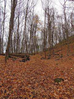
As we proceeded along the Bruce Trail we realized how different the pathway looked to our previous treks along it in the summer and fall. Given the season and the fact that the heavy rains and strong winds a week ago had brought down much of the fall foliage, we now walked through a landscape transformed. Instead of lush tree canopies and vibrant fall colours, we were now venturing through a relatively barren and exposed forest which allowed the seasonally cold winds to rush through. Additionally, around us, the popular waterfalls were either dry or frozen again reminding us that it was now closer to winter than summer.


The trail eventually led us back to the top of the escarpment which gave us a great view of Lake Ontario, off to the north, and of many vineyards and orchards on the flat land between the Great Lakes and the Niagara Escarpment. Perhaps this section also felt different because although we could see plenty of farmhouses, wineries, and occasional houses, we were wending our way through rural farm county, and had left the urban centers behind for now.
Louth Conservation Area
The first couple kilometres past
Rockway Community Centre were fairly gentle, with the trail mostly staying at
the top of the escarpment. Then we
reached a rather steep incline, when the trail transitioned to the bottom of
the escarpment, just before Louth
Conservation Area. The rain had left
the ground saturated with water and very muddy, and this was not helped by the
newly fallen leaves. While generally, we managed
to pick our way carefully to the bottom of the hill without incident, we must admit that at
one point Lenora lost her footing in the mud and went for a short slide. Unable to restrain myself I began to laugh - then I fell myself. Sliding through the mud downhill I was soon covered head to toe in a slick of gooey dampness. Sigh.


The stretch of pathway in Louth Conservation was hilly and very pretty. The trails here are extremely well-maintained. At one point it crossed Sixteen Mile Creek, and then re-joined it, weaving along beside the creek bed until it came to Louth Falls. This was a tall, thin waterfall, which had several shallow pools on the way down. Afterwards, the trail climbed slowly to arrive at the top of the falls, so Sean climbed to the bottom along established paths and across built wooden bridges to take photographs. While we hiked here in the late fall / early winter season it was easy to imagine how lush and colourful the spring flowers would be throughout this amazing region!


Estates and Wineries
Soon the Bruce Trail moved upward, eventually emerging on Staff Ave, some 50 meters from the parking lot for the Conservation Area. Staff Avenue is a narrow, paved country road with very narrow gravel edges, but - thankfully - there was no traffic while we were on it. We walked past the Sue-Ann Staff Estate Winery on our left, with its s-shaped red chain marker and large friendly dog. The vineyard was very pretty up close, and I was surprised to see that the grapes which had been left on the vines, presumably to make ice wine, were still plump and juicy looking, and not shrivelled up and raisin-like.


We had clearly left the forested conservation area behind as well as the rockiness of the Niagara Escarpment and exchanged them for open fields for a short period. Here again, the sounds of shots rang out across the fields startling us. We would later discover that they are air canons used by the wineries to scare off local birds who feast on the grapes.


Before ducking back into a short stretch of trail between some very nice houses we paused for a minute to identify the various pockets of development around the great lake that could be seen from even this distance. From here we could see the growth of regions like Burlington, Oakville, Mississauga, Toronto, Scarborough, and Pickering/Ajax.
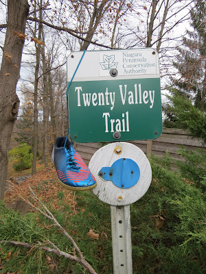
Twenty Valley Trail
We continued along the roadway and soon arrived at a short section of trail through a local green space. Here the BTC traverses a hilly, open, maple-beech-oak forest, in which we passed several other hikers. We emerged from this nice woodlot and crossed Nineteenth St. At this point we could see Jordan Harbour and the bridge over it for the QEW, which we later discovered is where Twenty Mile Creek empties into Lake Ontario.


Soon after leaving the road, we could hear the rushing of the water below, and the wider, flatter, gravelled trail soon began a rapid descent to the bottom of the gorge. There were a lot of hemlocks growing in the gorge, giving the trail a different feel. It was also quite an urban feeling, with trail garbage cans present, graffiti on the rocks, and carving on the trees. Near the southern end of the gorge, there was a beautiful waterfall. It was wide and not too tall, but it had quite a lot of water flowing over it.

After the waterfall, we again climbed a very long, steep set of stairs that led up the side of the gorge. Once at the top, we came out into the Ball’s Falls Conservation Area which is a nineteenth-century pioneer settlement with a series of mills, that has been restored to their original condition. Ball’s Falls was founded as Glen Elgin in 1783 by Loyalist Jacob Ball. The various mills, including a grist mill and saw mill were built in the early 1800s utilizing the Twenty Mile Creek for power. The Ball house and Lime Kilns were subsequently built in the 1840s adding to the region’s further development. In addition, British Troops were stationed at this location throughout the War of 1812 to protect regional industry and safeguard a local source of flour.


The trail led through an open grassy area with several historic buildings, including what looked like an old mill, a barn, a house, and a chapel. There was a wedding party having their photos taken near the buildings and the fall, as well as a family who were also having fall photos taken. After passing these buildings the trail led out to a wide, open, semi-circular look-out which provided a spectacular view of Ball's Falls. This is a wide, semi-circular waterfall, which is 27 m tall. It must be one of the largest falls we have passed on the trail so far. We crossed over Sixth Avenue and briefly left the trail to have lunch in the Ball's Falls Centre for Conservation. This was a very interesting building with many educational write-ups and photographs on the geography and biodiversity of the area, as well as a gift shop which happily sold hot coffee!


After lunch, we walked back out to the road, picked up the trail again, and headed north along the top of the gorge, on the opposite side. The trail first followed the road for a short distance and provided a different view of Ball's Falls. In this section, we passed a small puddle of blood, where some kind of animal had apparently been hit by a car. The trail then followed a thin strip of trees between two fields as it headed west again into a larger patch of forest. Here we encountered another group of four older hikers, also out enjoying the weather. We first passed the two ladies, who told us to tell their husbands they had fallen off the cliff if we caught up to them. We later met their husbands, duly waiting for them, as the trail emerged from the woods onto a gravel road.

At the end of this gravel drive, just
before the trail crossed Victoria Ave was a lovely hobby farm with gigantic
rabbits, chickens, goats, and a huge and wonderful vegetable garden complete with
a small greenhouse. There were ripe
raspberries and strawberries in the garden, which was a real inspiration to see
in the middle of November! Best of all, there was a large golden retriever
asleep in the field, who only roused himself when we slowed down to gawk at the
animals and the chickens began to take too much of an interest in us. The dog made sure no one was harming the
chickens and admonished them until they stopped following us.


Escarpment Vineyards
Once the trail crossed Victoria Avenue, a busy roadway, it descended the escarpment and wound through meadows, fields and vineyards. The Featherstone Winery was to the south of the trail, then the Vineland Estates Winery, and then the Tawse Winery to the south. The visitor centre for the Tawse Winery was clearly visible from the trail, and it was doing a brisk business, with several tour buses parked outside. After crossing Cherry Avenue we passed between more wineries - unknown to us these included Ridgeport Wines and Megalomaniac Wines. In this section, we also found several chunks of stone covered in fossils of seaweed. There were also some large slabs of limestone, like circular slices of rock, lying on the end beside the trail. It was difficult to guess how they came to be lying where they were as if they did not appear to have broken off the escarpment above.

Eventually, the trail entered the Cave Springs Conservation Area, by means of a very steep climb up to the top of the escarpment. At the bottom was the Cave Springs camp, with small cabins, a swimming pool, and a ropes course visible through the trees. The trail followed along the edge of the escarpment, giving spectacular views of the lake – especially as the leaves had long since dropped from the trees. There was a lot of ground pine along the trail, and shortly after entering the conservation area, we came across a small makeshift campsite, with a fire pit, benches, and evidence of several stick lean-tos.

There was little doubt in our minds that today’s hike and this stretch of the BTC seemed considerably harder than our previous treks given the number of gullies, inclines, and staircases en route. A combination of the two large, long and steep staircases, the path's continual movement up and down the escarpment, the rocky terrain and the slippery leaves on the pathway made much of today’s walking tiring. It is equally possible that it was not the challenges of the pathway but the fact that spending our days at desks in offices which did little to keep us in shape for these types of ventures that made the day tougher feeling.


Particularly striking throughout the hike today was the fact that the escarpment as well as both the limestone and dolostone rocks along the route were pockmarked with small divots as a result of decades of acid rain. Here the geology of the region was bared for all to examine it is remarkable to see how quickly and profoundly humanity has made an impact upon the natural world.

We followed the edge of the escarpment for
a few kilometres before the trail left and emerged onto Quarry Rd. a few meters
east of the parking spot. We finished
this leg of the hike around 4 in the afternoon, reclaimed our car and set off
to find a cafe to enjoy a well-deserved coffee and pastry while making plans
for our next hike.

Enjoying our time at the local Tim Hortons we received an interesting surprise when we discovered that Lenora had brought a couple of copies older Bruce Trail Guides (8th,10th and 15th editions) which she had stumbled upon and wanted us to see. In particular, she was impressed at how much the trail and clubs had developed and improved throughout such a short period of time. Indeed even just a quick perusal of the guide affirmed her assessment of the trail's progress in the previous four decades until our present guide which was the 27th edition. We were also particularly amazed by the artistic talent used in the hand drawings depicting parts of the trail and important sites in these historic guides.


-----
Distance: 45.1 - 65.0km
Duration: 9:15am - 4:00 pm (7 hours)
Comments
Post a Comment