Finishing Niagara on the Bruce Trail : Quarry Road to Grimsby
Finishing Niagara on the Bruce Trail
Quarry Road to Grimsby
We had originally planned to make Woolverton Rd the end of today's segment and thereby cover another 20km of the Bruce Trail. However, when the day began with cold winds, low temperatures, and heavy rains, our plans changed accordingly.
We met at 8:30am and decided that in order to make allowances for our likely slower progress along the muddy, slippery trail, we would stop at the border between the Niagara and Iroquoia sections instead. To this end, we headed for the little "P" symbol marked on the trail map at the end of Gibson Rd, right along the border. Gibson Rd turned out to be a very narrow street with residents' vehicles parked along both sides of the street and multiple 'No Parking' signs posted along the length. When we parked one car, a lady came out of a nearby house and we were soon told to move the car since parking was no longer allowed on the street for people walking the trail.

As a result, unable to figure out where the designated parking for the trail was, we decided to leave one of the cars at the back of the deserted parking lot for the Grimsby Lion's Community Pool on Elm St. instead. From there we headed back to Quarry Rd. where we left off last month.
For some reason, the drive back along the base of the escarpment seemed to be much longer than any section we had previously covered, even though it was in fact shorter! Sometimes it is amazing to see how our perspectives of the world change based on how we travel – whether by car, bus, on foot, or bike.


Resuming our trek amid a steady rainfall, along Bruce on Quarry Rd., we could see the old foundations of the Quarry building nearby. From Quarry Rd to Mountain Rd, the trail essentially followed along the top of the escarpment, through open maple-oak forest. Despite being December and almost Christmas the fall colours - now on the ground - were still vibrant around us. Looking north through the trees our view was cut short by clouds and fairly heavy rain, leaving us to wonder if we would have seen the lake from here on a clear day? At the base of the escarpment we first passed the vineyards associated with the Crown Bench Estates Winery. We then crossed a small footbridge over a picturesque stream and then progressed into Kinsman Park. As we approached Mountain Rd a rather affluent sub-division was visible below us through the trees, on the outskirts of Beamsville. Given the amount of development around the Great Lakes we were once again grateful for the work of so many throughout the decades in protecting much of the green space on and around the Niagara Escarpment.


Fall Colours and Rain Showers
On the west side of Mountain Rd, the trail continued along Leonard Crescent, a narrow laneway bordered by several houses nestled back in the trees. The end of the roadway where the trail picked up again was full of garbage of the sort that suggested this might be a lover's lane for local residents. As the trail threaded its way through the trees again, large yellow signs were posted every few meters reminding trail users that this was private property, that there were cameras monitoring the trail, and that any trespassers would be prosecuted. Regardless, we stuck to the trail and quietly meandered between the postings and continued on.

Given our pace, we had more time to look around as we sought to keep our footing. Interestingly the Escarpment rocks along the forest floor throughout this stretch were clearly heavily pock-marked, likely the result of years of exposure to acid rain. Even the rocky pathway itself was heavily worn from decades of hikers treading the route. It was stunning to realize that despite the Escarpment being centuries old it took people so little time to radically transform the geology and ecology of a region.
Continuing on the rain decided to stop drizzling and commence with a full deluge of the region. The result was that those moments earlier spent avoiding puddles and slipping down slopes were soon looked on fondly. Our trek quickly transformed into an obstacle course on which we merely sought to avoid twisting our ankles or falling too badly. At the same time pathway weaved and switchbacked a great deal which meant that we essentially hiked a km or two west and then followed the trail at the bottom of the escarpment back east. Sadly, though the view at the base of the escarpment was beautiful, there was once again a great deal of evidence of people having campfires and parties under the ledge of the escarpment.


Mountainview Conservation Area
We followed the trail along Locus Lane, which ran between rows of grapes, and then turned right onto Mountainview Rd. On one side were more houses, and on the other were vineyards for the Mike Weir and Organized Crime Wineries. Though we are no fans of road walking, especially when such roads have no shoulders for safe trekking, there is no denying that this stretch made for a nice break from slithering through the mud and climbing up and down the escarpment. Feeling as though we were the only ones dumb enough to be out in such weather we nonetheless passed a young lady jogging through the December rain in shorts and a tank-top. A few hundred meters down the road the trail turned into the parking lot for the Mountainview Conservation Area, which somewhat resembled a very large mud puddle.

Yet no gift is given without cost. Soon the trails narrowed out and were more akin to troughs of red clay mud than pathways which in turn led to sections where wet and slippery leaves filled the gaps between rocks making much of this region very difficult to navigate. Soaked through we again stopped to enjoy a quick snack and lunch beside a waterfall where three logs had been made into a U-shaped section to enjoy.


Venturing on Bruce Trail emerged from the conservation area through the side yard of someone's house, and turned north to follow Walker Rd. Here again, we had a short walk along a paved roadway and a too-short reprieve from the drenched pathways.
We had an orchard on one side for a bit and a row of rural houses on the other. At this point, the rain had picked up again, but just as we began to feel sorry for ourselves we were again passed a teenage girl jogging along the road in a sleeveless shirt and short shorts! Burr. Oh to have the strength and fortitude of youth again!
Niagara Escarpment
The trail soon left the road ducking into the trees and tracing the Niagara Escarpment again. Here our route was more direct including lots of hiking past backyards, pools, and roadways once in the city of Grimsby. At one point sections of the Bruce Trail literally passed through some people's backyards and between residential houses. While we were grateful for the right to pass through and their support of the Bruce trail system, these parts of the pathway felt somehow awkward to hike on for us. Regardless, as the BTC hiking guide notes, while this trail passes along and through a number of densely populated regions, in general hikers remain on a woodland path – which is quite impressive given the urban sprawl and growth of the Greater Hamilton region in recent years! Very true. While the Niagara Escarpment is protected as a green way and by its UNESCO designation there is no denying that one of the reasons that it has remained largely intact is the fact that it is precarious to build on, heavily log or develop. The truth of it is that its own fascinating geology has thankfully made it impractical to “modernize”.
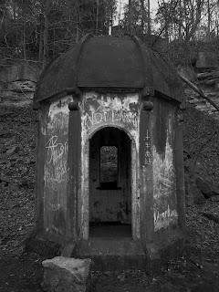

After crossing yet another Mountain Rd. we began our descent of Grimsby Mountain where we found a unique structure near the end of the trail in Grimsby – a small temple-like building. While there was no explanation onsite as to what this unique building was, after some research later on Lenora identified that the structure was set on the top of a historical water reservoir. After exploring the odd little building for some time we then rejoined the trail and continued our descent. We soon came out of the woods and followed the sidewalk into Grimsby towards Elm St. and the day’s end.
Moments later we arrived at a pedestrian footbridge crossing a rushing stream at the base of the escarpment. While nondescript in almost every way this bridge serves as the boundary between the Niagara and Iroquoia Sections of the Bruce Trail.

Excited that we had completed the first of nine Bruce Trail sections we returned to our car. As of today, we have now finished approximately 80 km of the 800-900 km which comprise the main Bruce Trail! Given the mud of the day and troubles navigating the pathway, we spent much of our drive home discussing the merits of getting hiking poles for future walks. While Sean remained convinced that they would serve as a headache and make him trip both Lenora and I were sure that their aid would have been invaluable today.
With our first section completed, we were now off back home to order our Niagara patches!
-----
Distance: 65.0 - 80.0km
Duration: 9:40am - 2:30 pm (5 hours)
Comments
Post a Comment