Slow and Steady on the Bruce Trail : Silent Valley to Sydenham Forest
Slow and Steady on the Bruce Trail
Bruce Trail and Trail Angels
Well rested
and with only partially dry shoes, our morning began with a quick trip to Tim
Hortons for large coffees and breakfast sandwiches before meeting up with a
local BTC Trail Angel who was helping us by driving us to the start of the
day’s hike. With our rental car parked
at the eastern edge of the Sydenham Forest, we were then transported back to
the Silent Valley Side Trail just north of Bognor
Marsh Management Area. Saying our
thanks and sliding on our day packs, we were soon back on the Bruce Trail.

Once again slack packing, we followed a logging road through a pine forest before climbing back up the 1.5-kilometre side trail onto the escarpment. As we discovered yesterday, much of this region was very rocky, which forced us to watch our footing constantly. After the tough climb, we were rewarded with terrific views of the pastoral landscape. The patchwork and developed nature of the properties around us once again made us grateful for the thin band of green space and dense forest which the Bruce Trail navigates and maintains. This is certainly no easy task in a modern world fixated on efficiency, clear-cutting, and development.
Back on the Bruce Trail
Back on
the main pathway of the Bruce Trail amid a beautiful and cool morning, our route continued to climb,
eventually leading us to another terrific lookout over the Bighead River Valley
below. From this point our path, having
reached the rim of the escarpment, had only one place to go – downhill. The descent was treacherous. At this point, we were reduced to navigating the
uneven terrain and slippery rocks on our butts.
We had to take our time weaving through the narrow crevices that the
pathway followed, and made good use of the installed ropes to keep our
footing. In this way, we slowly began trekking
north down the escarpment along a forested path before almost immediately climbing
back up again.

At times
the trail became incredibly narrow, only held in place on the steep slope by logs
intended to keep the compacted dirt from washing away. In these stretches, with the escarpment
rising up on one side and a sheer drop on the other, we were grateful to those
who maintained the pathway, and for the fact that we weren't carrying our
bulky, heavy backpacks today. Regardless of the challenges, it was a beautiful
region that gave us quite a workout as we navigated the rocky terrain that took
us past maple sugar lines, to a number of lookout points, and past a number of
deep crevices in the escarpment. To us, it is always fascinating to see that
many of the deep nooks and crannies in the escarpment are, even late into the
spring, still filled with patches of snow that emit huge drafts of cool air.
Our route
also took us past numerous small spring streams running downhill and over the
edge of the rocky ridge. Long before we
arrived, we could hear the roaring roadway ahead, and far too soon we walked
out of the stand of conifers that had been shading us and onto the edge of HWY
26. This busy roadway came as a shock to
us on the edge of the Bruce Trail. Not
only did the noise and stench of vehicles permeate the region – in strong contrast
to the peacefulness of the natural areas we have recently been treading across –
but at such dangerous roadways the BTC had previously done a marvellous job of
utilizing alternative routes, pedestrian bridges, or tunnels. Here there were no other options but to cross
the steady stream of speeding traffic flowing past. The process took us 20 minutes of waiting to
find a gap big enough, and safe enough, for us to run across the two lanes to
bring us to the community of Woodford.
Woodford Ontario
Off the
busy thoroughfare, we wandered past the quaint Woodford Community Centre and a
number of cozy homes. With a 2-kilometre
reprieve from local roadways, we crossed through the Woodford stretch of the BTC,
back into a dense conifer forest amid the geology of the escarpment and traces
of regional history. The first unique
site we came to was a stand of semicircular ruins on the side of the
ridge. According to the BTC guidebook,
this stone wall is the remains of an old limestone kiln speculated to have been
made from an old glacial pothole. This
historic site, long abandoned and fallen into disrepair, has given way to trees
that have since grown along the top of its remaining walls – though the hole at
the bottom is still very much in evidence.
Beyond
the kiln, the trail continued to meander around the mossy rocks and flowing
streams of the region. We were amazed by
the spectrum of greens which the various lush mosses and lichens frequently
gave way to along the Niagara Escarpment.
Not for the first time we both wished that we knew more about both bryology
(the study of mosses and liverworts) and geology (the study of how the earth
was formed, its structure and composition, as well as the types of processes
acting on it).
With our next road crossing within earshot, we passed the remains of a stone building whose walls stood along the trailside. Sadly, as with so much of Ontario’s local history, we could find nothing about this building to indicate its story.
With our next road crossing within earshot, we passed the remains of a stone building whose walls stood along the trailside. Sadly, as with so much of Ontario’s local history, we could find nothing about this building to indicate its story.
Tight Squeeze
Soon
after this, the Bruce Trail dropped into a very, very, very narrow crevice, the
nature of which should have been evident given the nature of the Bypass Side
Trail sign. It has long been our
experience that trail names are either fun in nature or warnings of what is to
come. This one was clearly the
latter. The unique trail sign in
question noted that: “The Trail ahead passes through a narrow crevice. Consider using bypass if carrying a large
backpack or if claustrophobic”. This was
an apt warning, given that we soon descended into a segment of the escarpment
that I am not entirely sure we could have navigated with our full backpacks
on. Indeed, at times even our small day
packs made weaving through it an adventure.
While neither of us suffers from claustrophobia or is generally too worried
about tight spaces, there was certainly something about squeezing through those
tight corridors of ancient stone that gave way to a duel sense of fascination
and fright. Navigating around large boulders, pushing through tight spaces, and
ducking under outcroppings made this stretch the very definition of cramped
quarters.

Bayview Escarpment Provincial Nature Reserve
With the Bruce Trail back off the roadway, we followed the white blazes along a hedgerow and property line, tracing along the edge of freshly plowed fields toward the Bayview Escarpment Provincial Nature Reserve. En route, we were met by a flock of sheep whose curiosity led them to follow us along a nearby electric fence. In short order, we left the muddy track behind and crossed a bridge, as well as a succession of stiles before turning north. To our dismay, we discovered that our route was not so much a trail as it was a muddy logging or farming road, which had recently been churned up into a thick morass by the combination of recent rainfall and local vehicles.
Slogging on, the trail traced the edge of the Niagara Escarpment, which continued to provide amazing views over the surrounding landscape, as well as glimpses of Georgian Bay. This was a wonderful stretch, perhaps best defined as a beautiful ridge walk. This section of the Bruce Trail, as seems par for the course, continued to present somewhat of a challenge given the rocky terrain, which required that much of our attention remain focused on our feet. Regardless, we were nonetheless fascinated to come across a number of large boulders (likely glacial erratic), which were scattered across the top of the escarpment and throughout the property. Perhaps more stunningly, throughout this stretch strong winds buffeted the escarpment and made the canopy of the trees above us wave and shake as though the entire forest was breathing in deeply. It seemed as though nature was reminding us that boulders weighing several tons can indeed move and that trees do dance!
Along the
escarpment, we also skirted around a military base – the Meaford Land Forces
Training Centre, also known as the Meaford Tank Range. This discovery, as well as the ongoing
artillery blasts, answered a growing mystery for us. Over the course of the last few days, we had
heard loud explosions which had reverberated throughout the region but had
been unable to guess what caused them.
Our arrival at the fence line denoting the Department of National
Defense boundary, with its warning signs indicating that “this is a military
target area. Do not touch anything. It may explode and kill you” provided the
answer. With this advice in mind, we
kept our eyes open and our hands to ourselves as we proceeded.
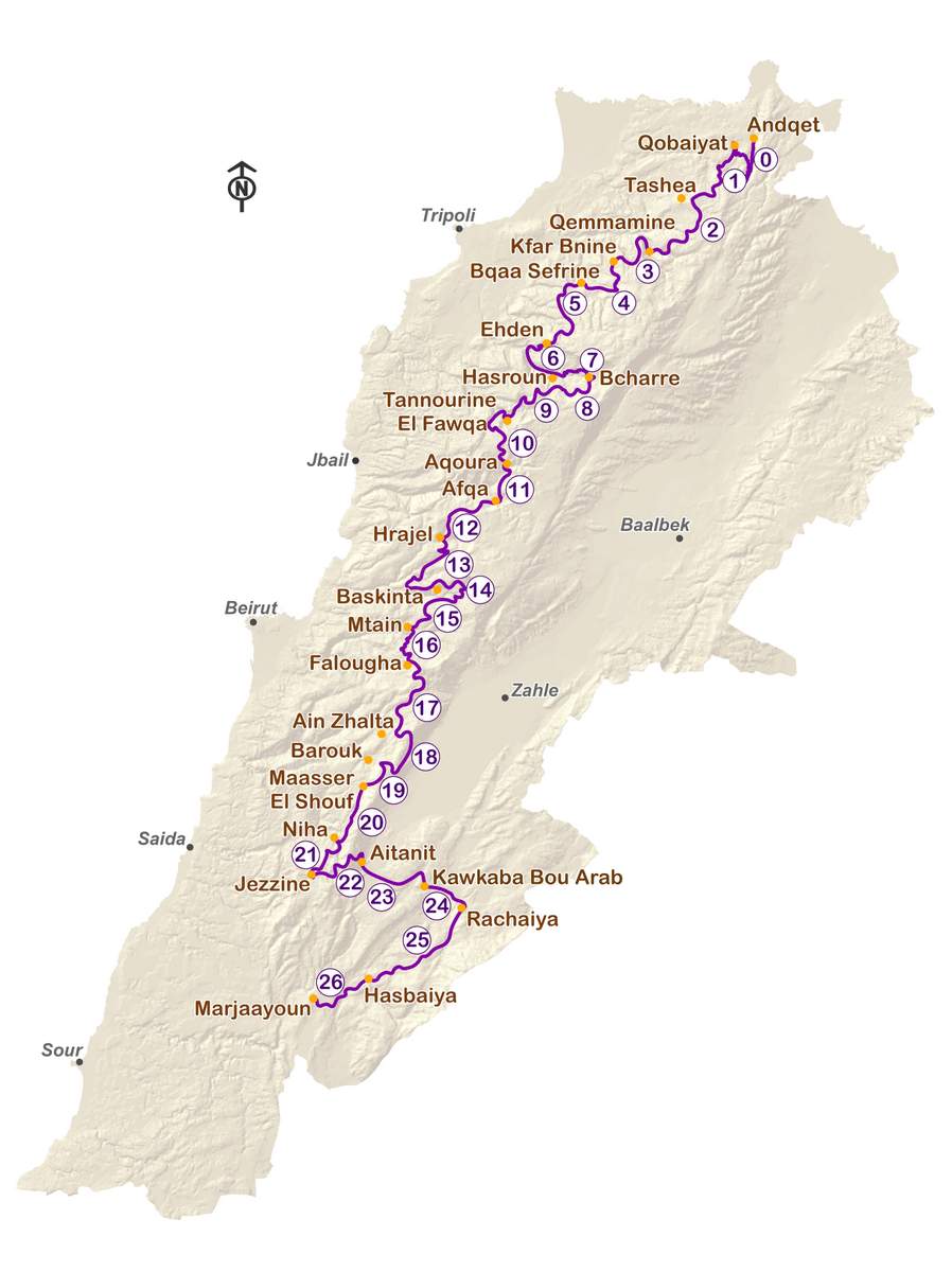
Lebanon Mountain Friendship Trail
Also
inside the Bayview Escarpment Nature Reserve is the Lebanon Mountain Trail-Bruce Trail Friendship Trail. Established in 2007 as a means of
developing ecotourism in the country, the Lebanon Mountain Trail is 470
kilometres in length and navigates some of the nation’s remote mountainous
regions. The trail itself runs from the village of Andqet in the north to
Marjaayoun in the south. Along the way,
it ventures through more than 76 villages and towns, as well as passing
through UNESCO Heritage Sites, and exploring amazing natural preserves such as
the Al-Shouf Cedar Nature Reserve, the Qadish Valley, the Wadi Jahannam, and the
Akkar mountains.

Tom Thomson Trail
Now
almost 20 kilometres into our day’s hike, we took a break at the BTC parking
area and juncture of the Bayview Nature Reserve and St. Vincent-Sydenham
Townline. There we found signs for the
Tom Thomson Trail – a pathway which joins Meaford and Owen Sound. Unfortunately, much like the BTC in this
region, this stretch of the Tom Thomson Trail utilizes roadways, side roads,
and concessions to excess. I suppose the reality is that some areas are just
not suited to off-road trail development.

A commercial designer by trade, Thomson spent much of his time exploring
Ontario’s north and the Algonquin region as a painter. The results from his forays and his time
spent as a guide and woodsman soon made him one of the nation’s greatest
painters. Thomson’s art reflected his
interest in changes in the seasons, weather, and lighting across Ontario’s
natural areas. The time he spent with
his friends, Lawren Harris and A.Y. Jackson, would influence them as they went
on to form the Group of Seven.

Thomson
is officially listed as having drowned in a canoe accident in Algonquin Park in
1917. However, his passing has given way
to one of Canada’s enduring mysteries.
The Tom Thomson Trail passes
the historic Leith Church and cemetery where the young artist is rumoured to be
buried.
A Long Road Walk
Setting off again, we crossed the boundary of the Bayview Escarpment Provincial Nature Reserve and began what would be a 10-12 kilometre trek that primarily boxed along country roadways. Much of this stretch, including the St. Vincent-Sydenham Townline, Sideroad 24, the 2nd Concession, and Sideroad 22 consisted of long unbroken gravel roads, which went off onto the horizon in front of us. While they admittedly did provide expansive views of the rural landscape, they were nonetheless tough. These quiet, tree-lined country roads were dotted with stone houses and iconic red barns. The endless crunching of our footsteps was punctuated by the loud, repetitive keening of Killdeers on the edge of plowed fields and the iconic screams of Red-tailed Hawks calling overhead.
After almost two hours of walking, our long road trek was interrupted as the path of the Bruce Trail turned and passed through an overgrown hawthorn hedge and began to climb the escarpment. Back in a forest, we enjoyed our walk as the rocky terrain of the escarpment again made itself evident. Passing a sign for the Beaver Spring Side Trail, a BTC wetland, we left the forest and traced the edge of a plowed field. After this, in short order, we crossed Irish Block Rd, traced the escarpment edge through a brief forest, and stepped back out onto the busy HWY 26 – the same roaring highway we had earlier dealt with outside of the community of Woodford. By our calculations, we were now approximately 4 km away from our last juncture with this highway, having taken 23 km of pathway along the route of the Bruce Trail to get there.
.jpg)
I have to admit that few things are more nerve-wracking than hearing a transport coming, feeling your body tense, and then being buffeted by the wave of air created as the giant vehicle races past. We each have different reactions to this type of situation – I grip my hiking poles harder and stay as far onto the shoulder as I can, alternatively, Sean walks much, much, quicker. As a result, we were soon separated by a fair distance. All in all, it was not an enjoyable stretch and one of the few sections where I believe the BTC should reconsider the trail’s route if at all possible.
Farmlands and Fence Lines
Reaching the corner of a farm fence line, and a point at which the escarpment rose up out of the landscape once again, we turned down a densely shaded property line that would take us north. We were extremely grateful to put the rush of traffic behind us. Within several dozen feet it seemed as though even the roar of the traffic was being held back by the brush and forest canopy – the blessings of nature! No longer focused on merely surviving, we again began to notice the world around us. Nearby squirrels called out as we passed, birds were racing across the pathway, already gathering food for young nestlings, and overhead was a near-constant stream of small Cessna airplanes - likely coming or going from the Billy Bishop regional airport..JPG)
Reflecting
Throughout
the evening we talked about one of our central frustrations during our hikes –
road walking, which was a fitting topic for the day’s trek on the Bruce Trail.To go out
walking in the digital age of efficiency, quick answers and instant
gratification was once described to us as a “radical act”. In many ways, hiking is the direct
antithesis of modernity. Take the BTC
for instance. Someone who drives from
Queenston Heights to Tobermory will travel approximately 380 km. Someone who follows the Bruce Trail between
the same two points will hike nearly 900 km.
This disparity exists in each section.
In Sydenham, the distance between Bognor Marsh (today’s starting point)
and Owen Sound (tomorrow’s destination) is a mere 17.2 kilometres by road. In contrast, the path of the Bruce Trail is almost
60 kilometres. Clearly, when setting out
on the Bruce Trail we aren’t expecting to take the most direct route, but are
instead looking to slow down, see the world differently, and push our boundaries.
So why
does trekking on roadways and gravel concessions bother us so much? Why does
the Bruce Trail’s recent fascination with boxing along concessions – at times
bringing one back almost to the point of departure – frustrate us so much?
Especially if we earnestly believe that the hike is about the journey, not the
destination.
.jpg)

Thank you to the Bruce Trail Builders
None of this debate should be taken as criticism of the Bruce Trail Conservancy – merely a critique of our own hang-ups amid a bout of self-reflection.
See you on the Trail!
Comments
Post a Comment